IMAGES TAKEN NEAR TO
Rigbys Row, NANTWICH, CW5 5RX
Introduction
This page details the photographs taken nearby to Rigbys Row, CW5 5RX by members of the Geograph project.
The Geograph project started in 2005 with the aim of publishing, organising and preserving representative images for every square kilometre of Great Britain, Ireland and the Isle of Man.

There are currently over 7.5m images from over14,400 individuals and you can help contribute to the project by visiting https://www.geograph.org.uk
Image Map
Images are licensed for reuse under creativecommons.org/licenses/by-sa/2.0
Notes
- Clicking on the map will re-center to the selected point.
- The higher the marker number, the further away the image location is from the centre of the postcode.
Image Listing (387 Images Found)
Images are licensed for reuse under creativecommons.org/licenses/by-sa/2.0
Image
Details
Distance
1
Nantwich Exchange
Nantwich Exchange (identifier WMNAN) is BT premises set back from the north side of Hospital Street.
Image: © Jaggery
Taken: 13 Oct 2016
0.01 miles
2
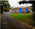
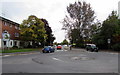
West along South Crofts, Nantwich
South Crofts is a cul-de-sac on the west side of Millstone Lane. The car is on the corner of North Crofts.
Image: © Jaggery
Taken: 13 Oct 2016
0.03 miles
3
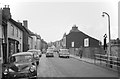
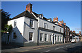
Hospital Street, Nantwich ? 1963
At this time it still carried through traffic from the east making its way to the A530.
Image: © Alan Murray-Rust
Taken: 15 Sep 1963
0.04 miles
4
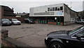
C. Latham Motors, Nantwich
Garage set back from Hospital Street.
Image: © Jaggery
Taken: 13 Oct 2016
0.05 miles
5
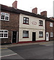
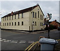
Former Cheshire Hounds pub, Hospital Street, Nantwich
Now in residential use.
Image: © Jaggery
Taken: 13 Oct 2016
0.05 miles
6
WeaverHouse, Hospital Street, Nantwich
WeaverHouse (no space between r and H) is an osteopathic and natural health care practice at 126 Hospital Street.
Image: © Jaggery
Taken: 13 Oct 2016
0.06 miles
7
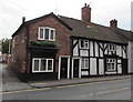
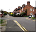
Three Grade II listed houses in Hospital Street, Nantwich
There are many listed buildings in Hospital Street Nantwich. In view are number 134 on the corner of Spring Gardens and black and white timber framed numbers 132 and 130.
Image: © Jaggery
Taken: 13 Oct 2016
0.06 miles
8
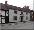
140-142 Hospital Street, Nantwich
View west along Hospital Street, early on a summer's morning, near the Churche's Mansion roundabouts. The grade-II-listed white-rendered building (left) is 140-142 Hospital Street, dating originally from the 17th century and on the site of the Hospice of St Nicholas of 1083 which gives the street its name. A plaque claims it is the birthplace of Randulph Crewe, who became Lord Chief Justice in 1625. The building to its right (136-138 Hospital Street) is also listed, as are several others also visible (right). For more details, see: http://en.wikipedia.org/wiki/Listed_buildings_in_Nantwich%2C_Cheshire
Image: © Espresso Addict
Taken: 11 Aug 2007
0.06 miles
9
Hospital Street mini-roundabout, Nantwich
At the Pratchitts Row junction.
Image: © Jaggery
Taken: 13 Oct 2016
0.07 miles
10
Globe House, Nantwich
Many-windowed office building on the corner of Hospital Street and The Gullet.
The entrance is at the left end of the building, from The Gullet.
Image: © Jaggery
Taken: 13 Oct 2016
0.07 miles