IMAGES TAKEN NEAR TO
Copes Lane, NANTWICH, CW5 5HU
Introduction
This page details the photographs taken nearby to Copes Lane, CW5 5HU by members of the Geograph project.
The Geograph project started in 2005 with the aim of publishing, organising and preserving representative images for every square kilometre of Great Britain, Ireland and the Isle of Man.

There are currently over 7.5m images from over14,400 individuals and you can help contribute to the project by visiting https://www.geograph.org.uk
Image Map
Images are licensed for reuse under creativecommons.org/licenses/by-sa/2.0
Notes
- Clicking on the map will re-center to the selected point.
- The higher the marker number, the further away the image location is from the centre of the postcode.
Image Listing (29 Images Found)
Images are licensed for reuse under creativecommons.org/licenses/by-sa/2.0
Image
Details
Distance
1
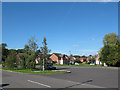
Edmund Wright Way, Nantwich
This section of the road forms an oval loop, possibly intended as a bus turning circle, and on the island are ventilation pipes suggesting there may be a septic tank or sewer overflow beneath.
Image: © Stephen Craven
Taken: 27 Sep 2015
0.07 miles
2
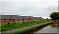
Suburban housing below Nantwich Aqueduct
A relatively unusual towpath-level view of a modern housing development.
Image: © David Martin
Taken: 28 Jul 2015
0.09 miles
3
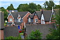
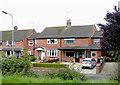
Cartlake Close, Nantwich
Modern detached houses off Edmund Wright Way.
Image: © Stephen McKay
Taken: 14 May 2017
0.10 miles
4
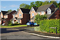
New housing at Nantwich, Cheshire
These new houses off Marsh Lane are close by the embankment supporting the Shropshire Union Canal. I can't find them marked on maps or shown on aerial images yet.
Image: © Roger D Kidd
Taken: 16 Sep 2015
0.12 miles
5
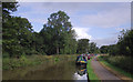
Shropshire Union Canal near Nantwich, Shropshire
The canal skirts the western part of the town (off to the right) on a long high embankment. Good visitor moorings are here, but they often fill up during good weather in the summer holiday period.
Image: © Roger D Kidd
Taken: 27 Aug 2011
0.17 miles
6
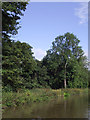
Shropshire Union Canal at Nantwich, Cheshire
The canal is on a long wooded embankment to the west of the town.
Image: © Roger D Kidd
Taken: 23 May 2009
0.18 miles
7
Housing at the edge of Nantwich, Cheshire
This is Marsh Lane by the Shropshire Union Canal north of Marsh Lane Bridge.
Image: © Roger D Kidd
Taken: 16 Sep 2015
0.20 miles
8
Shropshire Union Canal near Nantwich, Cheshire
The canal skirts the western part of the town (off to the right) on a long high embankment
Image: © Roger D Kidd
Taken: 27 Aug 2011
0.20 miles
9
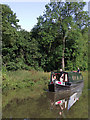
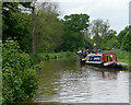
Narrowboat near Nantwich, Cheshire
The canal skirts the western part of the town (off to the right) on a long high embankment.
Image: © Roger D Kidd
Taken: 27 Aug 2011
0.20 miles
10
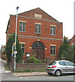
Former Methodist Chapel, Welsh Row, W Nantwich
Red-brick, two-storey, grade II-listed, former Primitive Methodist Chapel, on the south side of Welsh Row; the plaque dates the building at 1840. Recently disused and currently on the market. For more information, see: http://www.imagesofengland.org.uk/search/details.aspx?id=431672
Image: © Espresso Addict
Taken: 16 Oct 2006
0.20 miles