IMAGES TAKEN NEAR TO
Heron Way, NANTWICH, CW5 5GS
Introduction
This page details the photographs taken nearby to Heron Way, CW5 5GS by members of the Geograph project.
The Geograph project started in 2005 with the aim of publishing, organising and preserving representative images for every square kilometre of Great Britain, Ireland and the Isle of Man.

There are currently over 7.5m images from over14,400 individuals and you can help contribute to the project by visiting https://www.geograph.org.uk
Image Map
Images are licensed for reuse under creativecommons.org/licenses/by-sa/2.0
Notes
- Clicking on the map will re-center to the selected point.
- The higher the marker number, the further away the image location is from the centre of the postcode.
Image Listing (75 Images Found)
Images are licensed for reuse under creativecommons.org/licenses/by-sa/2.0
Image
Details
Distance
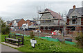
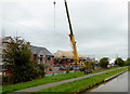
1
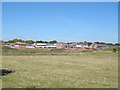
Malbank Waters under construction (1)
A new housing estate by the canal on the south-eastern edge of Nantwich. Seen from the bridleway on Green Lane.
Image: © Stephen Craven
Taken: 27 Sep 2015
0.04 miles
2
Malbank Waters under construction (2)
A new housing estate by the canal on the south-eastern edge of Nantwich. Seen from the bridleway on Green Lane.
Image: © Stephen Craven
Taken: 27 Sep 2015
0.04 miles
3
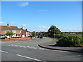
Housing estate, SW Nantwich
An extensive estate of semi-detached houses is situated to the SW of Nantwich. The majority of the houses probably date from the 1950s, with more recent additions. This view shows the junction of Queens Drive and Marsh Lane at the south-west corner, by the Shropshire Union Canal. Fields Farm is visible on the right of frame
Image: © Espresso Addict
Taken: 9 Oct 2006
0.06 miles
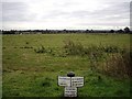
5
Canal milepost
This mile post lies just north of Green Lane Bridge on the Shropshire Union Canal close to Nantwich.
Image: © Colin Park
Taken: 7 Mar 2010
0.07 miles
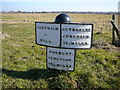
6
View over fields from Shropshire Union Canal
The milepost reads
Nantwich 1 mile
Autherley Junction 38miles
Norbury Junction 22.4miles
Image: © Ian Bottomley
Taken: 22 Sep 2007
0.07 miles
7
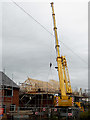
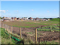
New housing development near Nantwich, Cheshire
This is by the Shropshire Union Canal south of Marsh Lane Bridge, No 91.
Image: © Roger D Kidd
Taken: 16 Sep 2015
0.08 miles
8
New housing south of Nantwich, Cheshire
A new estate being built by the Shropshire Union Canal south of Marsh Lane Bridge, No 91.
Image: © Roger D Kidd
Taken: 16 Sep 2015
0.08 miles
9
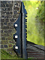
Bridge Protector
Situated at the side of the Shropshire Union Canal, these cast iron devices were fitted to prevent damage to the bridge masonry from the ropes that the horses pulled the barges with. The grooves were made through decades of rope wear.
Image: © Andy Beecroft
Taken: 16 Aug 2009
0.09 miles
10
Canalside new housing near Nantwich, Cheshire
A new estate being built by the Shropshire Union Canal south of Marsh Lane Bridge, No 91.
Image: © Roger D Kidd
Taken: 16 Sep 2015
0.09 miles