IMAGES TAKEN NEAR TO
St. Annes Court, NANTWICH, CW5 5GP
Introduction
This page details the photographs taken nearby to St. Annes Court, CW5 5GP by members of the Geograph project.
The Geograph project started in 2005 with the aim of publishing, organising and preserving representative images for every square kilometre of Great Britain, Ireland and the Isle of Man.

There are currently over 7.5m images from over14,400 individuals and you can help contribute to the project by visiting https://www.geograph.org.uk
Image Map
Images are licensed for reuse under creativecommons.org/licenses/by-sa/2.0
Notes
- Clicking on the map will re-center to the selected point.
- The higher the marker number, the further away the image location is from the centre of the postcode.
Image Listing (327 Images Found)
Images are licensed for reuse under creativecommons.org/licenses/by-sa/2.0
Image
Details
Distance
1
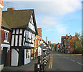
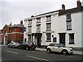
48 Welsh Row, W Nantwich
View east along Welsh Row towards St Mary's Church (in Image). In the left foreground is a grade-II-listed timber-frame building, the upper storeys of which overhang the street
Image: © Espresso Addict
Taken: 29 Oct 2006
0.03 miles
2
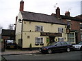
The Oddfellows Pub, Nantwich
Welsh Row, NANTWICH CW5 5ET close to The Shropshire Union Canal
Image: © canalandriversidepubs co uk
Taken: 30 Mar 2010
0.03 miles
3
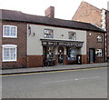
Jackson Opticians in Nantwich
S W & C Jackson Opticians at 43-45 Welsh Row.
Image: © Jaggery
Taken: 26 Oct 2016
0.03 miles
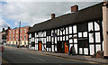
4
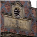
Grade II listed 39 Welsh Row, Nantwich
The building dated 1846 https://www.geograph.org.uk/photo/5651206 was originally a savings bank. Pevsner described number 39 as the first noteworthy building on Welsh Row which he considered the best street in Nantwich. Grade II listed in 1973.
Image: © Jaggery
Taken: 26 Oct 2016
0.03 miles
5
Roman numerals on 39 Welsh Row, Nantwich
The Roman numerals on this https://www.geograph.org.uk/photo/5651205 building indicate 1846.
Image: © Jaggery
Taken: 26 Oct 2016
0.03 miles
6
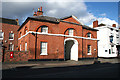
The Gateway, 60-62 Welsh Row
An unusual pair of houses which flank the arched entrance to the Porch House (not visible from the street). They date from the early 19th century and are grade II listed. To the right is Red Lion Lane and the Wilbraham Arms, formerly the Red Lyon Inn. For more detail, see http://www.imagesofengland.org.uk/details/default.aspx?id=431707
Image: © Espresso Addict
Taken: 3 Mar 2008
0.04 miles
7
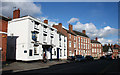
Wilbraham Arms, Welsh Row
Originally the Red Lyon Inn, the Wilbraham Arms dates from the late 18th/early 19th century and is grade II listed. Almost all of the buildings pictured to the right are listed. For more details, see http://www.imagesofengland.org.uk/details/default.aspx?id=431704
Image: © Espresso Addict
Taken: 3 Mar 2008
0.04 miles
8
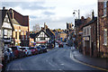
Welsh Row, Nantwich
Traditionally this was the main route into Nantwich from the west; it is now by-passed making it possible for the photographer to step out into the road safely. This is the view towards the bridge over the River Weaver and the town centre.
Image: © Stephen McKay
Taken: 29 Dec 2017
0.04 miles
9
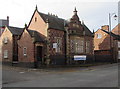
The Wilbraham Arms Pub, Nantwich
Welsh Row, NANTWICH CH5 5EJ close to The Shropshire Union Canal
Image: © canalandriversidepubs co uk
Taken: 30 Mar 2010
0.04 miles
10
Former Cheshire Cat, 26?30 Welsh Row
Welsh Row, now 'Curshaws at the Cat', previously the Cheshire Cat public house, was originally widows' almshouses donated by Roger Wilbraham in 1676. The building next door (left) is among the newest in Nantwich, a poor imitation of the Georgian townhouses on Welsh Row, such as no. 50, just visible at the far left. The steps (right) are a mounting block, cut from a single block of sandstone. For more details, see http://en.wikipedia.org/wiki/Listed_buildings_in_Nantwich%2C_Cheshire
Image: © Espresso Addict
Taken: 24 Aug 2007
0.04 miles