IMAGES TAKEN NEAR TO
Taylor Drive, NANTWICH, CW5 5GG
Introduction
This page details the photographs taken nearby to Taylor Drive, CW5 5GG by members of the Geograph project.
The Geograph project started in 2005 with the aim of publishing, organising and preserving representative images for every square kilometre of Great Britain, Ireland and the Isle of Man.

There are currently over 7.5m images from over14,400 individuals and you can help contribute to the project by visiting https://www.geograph.org.uk
Image Map
Images are licensed for reuse under creativecommons.org/licenses/by-sa/2.0
Notes
- Clicking on the map will re-center to the selected point.
- The higher the marker number, the further away the image location is from the centre of the postcode.
Image Listing (164 Images Found)
Images are licensed for reuse under creativecommons.org/licenses/by-sa/2.0
Image
Details
Distance
1
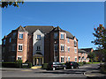
Taylor Drive, Nantwich
Three-storey houses on a fairly recent housing estate.
Image: © Stephen Craven
Taken: 27 Sep 2015
0.02 miles
2
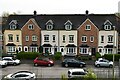
Acton: Taylor Rise from the Shropshire Union Canal embankment
Image: © Michael Garlick
Taken: 2 May 2024
0.03 miles
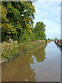
3
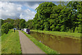
Shropshire Union Canal, Nantwich
There are visitor moorings on the towpath side south of Nantwich aqueduct.
Image: © Stephen McKay
Taken: 14 May 2017
0.05 miles
4
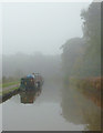
Foggy morning on the canal near Nantwich, Cheshire
Shropshire Union Canal.
08:56 GMT
Image: © Roger D Kidd
Taken: 21 Oct 2012
0.05 miles
5
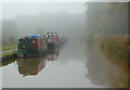
Foggy morning on the canal near Nantwich, Cheshire
Shropshire Union Canal.
08:57 GMT
Image: © Roger D Kidd
Taken: 21 Oct 2012
0.05 miles
6
Shropshire Union Canal near Nantwich, Cheshire
Looking north-north-east, the Shropshire Union Canal skirts the western boundary of the town on a long embankment. In this view, many narrowboats are moored on the approach to the aqueduct crossing the B5341.
Image: © Roger D Kidd
Taken: 19 Oct 2012
0.05 miles
7
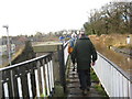
Walkers on the Aqueduct
Walkers going south over the aqueduct
Image: © Peter Fleming
Taken: 21 Dec 2008
0.05 miles
8

Acton, The Shropshire Union Canal: Viola Yesterday Today and Tomorrow presumably waiting to be planted somewhere
Image: © Michael Garlick
Taken: 2 May 2024
0.05 miles
9
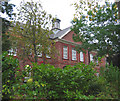
Malbank School, Welsh Row, W Nantwich
Large red-brick building dating from c. 1921 at the west end of Welsh Row, near the Nantwich aqueduct; now a school and sixth form college
Image: © Espresso Addict
Taken: 16 Oct 2006
0.05 miles
10
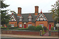
Wilbraham's Almshouses, Welsh Row, W Nantwich
Grade II listed, gabled red-brick terrace of three cottages, dated 1870, formerly almshouses; one of a pair on the north side of Welsh Row, adjacent to Malbank School. The plaques with coats of arms above the doors (centre) perhaps relate to the original almshouse charities. The timber trimming, prominent chimneys and geometric patterned windows are characteristic of many cottages in the Nantwich area (see, for example, Image). For more information, see: http://www.imagesofengland.org.uk/search/details.aspx?id=431734
Image: © Espresso Addict
Taken: 16 Oct 2006
0.05 miles