IMAGES TAKEN NEAR TO
Pall Mall, NANTWICH, CW5 5BN
Introduction
This page details the photographs taken nearby to Pall Mall, CW5 5BN by members of the Geograph project.
The Geograph project started in 2005 with the aim of publishing, organising and preserving representative images for every square kilometre of Great Britain, Ireland and the Isle of Man.

There are currently over 7.5m images from over14,400 individuals and you can help contribute to the project by visiting https://www.geograph.org.uk
Image Map
Images are licensed for reuse under creativecommons.org/licenses/by-sa/2.0
Notes
- Clicking on the map will re-center to the selected point.
- The higher the marker number, the further away the image location is from the centre of the postcode.
Image Listing (517 Images Found)
Images are licensed for reuse under creativecommons.org/licenses/by-sa/2.0
Image
Details
Distance
1
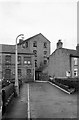
Pall Mall, Nantwich ? 1963
The tall mill has been demolished, the smaller one to the left has been converted to residential use.
At the end of the road Pall Mall continues as a narrow alley http://www.geograph.org.uk/photo/6484388 through to Hospital Street.
Image: © Alan Murray-Rust
Taken: 15 Sep 1963
0.01 miles
2

Music Recital in Nantwich Museum
A recital of 17th century music in Nantwich Museum, part of the events of Holly Holy Day.
Image: © Jeff Buck
Taken: 24 Jan 2015
0.02 miles
3
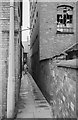
Pall Mall, Nantwich ? 1963
Typical alleyway of medieval origin, giving access originally to plots at the rear of houses. The industrial building on the right has since been demolished, the space now being occupied by a private car park.
Image: © Alan Murray-Rust
Taken: 15 Sep 1963
0.03 miles
4
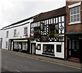
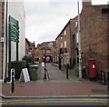
Vine Inn, Nantwich
The Hospital Street pub's nameboard shows VINE INN Circa 1641. http://www.geograph.org.uk/photo/5161569 to the name sign.
Grade II listed in 1974.
Image: © Jaggery
Taken: 13 Oct 2016
0.03 miles
5
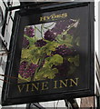
Vine Inn name sign, Nantwich
Hanging from a wall bracket here. http://www.geograph.org.uk/photo/5161559
Image: © Jaggery
Taken: 13 Oct 2016
0.03 miles
6
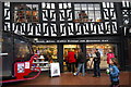
Nantwich book shop, and cafe (upstairs)
Built in the late 16th century this is a lovely independent bookshop with a nice cafe on the 1st floor. Was here for a signing session for my brother-in-law's first book, which went very well (if you like a bit of Monty Python / Terry Pratchett type fantasy I highly recommend it - Jonathan Eaves, Rude Awakening)
Image: © hayley green
Taken: 21 Nov 2009
0.03 miles
7
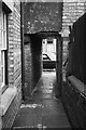
Pall Mall, Nantwich ? 1963
Typical alleyway of probably medieval origin, giving access originally to plots at the rear of houses.
Image: © Alan Murray-Rust
Taken: 15 Sep 1963
0.03 miles
8
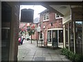
Nantwich: Cocoa Yard
Now a small shopping arcade, the Cocoa Yard (formerly Cocoa House Yard) is named for the nearby Cocoa House on Pillory Street, built during the Victorian temperance movement (thanks to Espresso Addict for this description).
Image: © Jonathan Hutchins
Taken: 4 Sep 2016
0.03 miles
9
The Cocoa Yard, Nantwich
Shopping area set back from the south side of Hospital Street.
Image: © Jaggery
Taken: 13 Oct 2016
0.03 miles
10
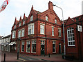
Victoria Cocoa House, Pillory Street
The red-brick Victoria Cocoa House stands next to Nantwich Museum on Pillory Street. A plaque states that the Three Cups Cocoa House moved to this site in 1897, providing accommodation, reading and meeting rooms as well as non-alcoholic drinks
Image: © Espresso Addict
Taken: 17 Jun 2010
0.03 miles