IMAGES TAKEN NEAR TO
Middlewich Road, CREWE, CW4 8HH
Introduction
This page details the photographs taken nearby to Middlewich Road, CW4 8HH by members of the Geograph project.
The Geograph project started in 2005 with the aim of publishing, organising and preserving representative images for every square kilometre of Great Britain, Ireland and the Isle of Man.

There are currently over 7.5m images from over14,400 individuals and you can help contribute to the project by visiting https://www.geograph.org.uk
Image Map
Images are licensed for reuse under creativecommons.org/licenses/by-sa/2.0
Notes
- Clicking on the map will re-center to the selected point.
- The higher the marker number, the further away the image location is from the centre of the postcode.
Image Listing (6 Images Found)
Images are licensed for reuse under creativecommons.org/licenses/by-sa/2.0
Image
Details
Distance
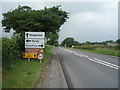
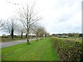
1
Middlewich Road, looking east
Near the junction with King's Lane. This is the 'new' alignment, created when the M6 was built in 1963 - hence the wide verges and row of trees.
Image: © Christine Johnstone
Taken: 30 Mar 2017
0.10 miles
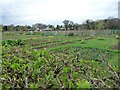
2
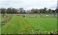
Plant beds, north of Middlewich Road, near King's Lane
Are these new allotments? Or a plant nursery? There's a lot of mown grass between the beds.
Image: © Christine Johnstone
Taken: 30 Mar 2017
0.11 miles
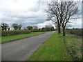
3
Middlewich Road, looking west
West of the junction with King's Lane. This is the 'new' alignment, created when the M6 was built in 1963 - hence the wide verges and row of trees.
Image: © Christine Johnstone
Taken: 30 Mar 2017
0.14 miles
4
Plant beds, north of Middlewich Road
Are these new allotments? Or a plant nursery? There's a lot of mown grass between the beds.
Image: © Christine Johnstone
Taken: 30 Mar 2017
0.15 miles
5
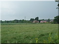
Farmland towards Middlewich Road
Off Knutsford Road (A50).
Image: © JThomas
Taken: 11 Jun 2016
0.17 miles