IMAGES TAKEN NEAR TO
Ribble Close, CREWE, CW4 8FR
Introduction
This page details the photographs taken nearby to Ribble Close, CW4 8FR by members of the Geograph project.
The Geograph project started in 2005 with the aim of publishing, organising and preserving representative images for every square kilometre of Great Britain, Ireland and the Isle of Man.

There are currently over 7.5m images from over14,400 individuals and you can help contribute to the project by visiting https://www.geograph.org.uk
Image Map (Loading...)


Getting Data...Please wait
Leaflet Map data © OpenStreetMap
Images are licensed for reuse under creativecommons.org/licenses/by-sa/2.0
Notes
- Clicking on the map will re-center to the selected point.
- The higher the marker number, the further away the image location is from the centre of the postcode.
Image Listing (5 Images Found)
Images are licensed for reuse under creativecommons.org/licenses/by-sa/2.0
Image
Details
Distance
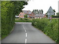
3
Farm track off the A54
Private drive to Bellfield Farm.
Image: © Jonathan Billinger
Taken: 6 Sep 2016
0.21 miles
4
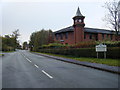
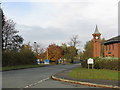
Station Road and Business Park Clock Tower
Image: © Colin Pyle
Taken: 23 Oct 2010
0.23 miles
5
Business Park Clock Tower, Holmes Chapel
Image: © Peter Whatley
Taken: 29 Oct 2009
0.23 miles