IMAGES TAKEN NEAR TO
Blackden, CREWE, CW4 8DQ
Introduction
This page details the photographs taken nearby to Blackden, CW4 8DQ by members of the Geograph project.
The Geograph project started in 2005 with the aim of publishing, organising and preserving representative images for every square kilometre of Great Britain, Ireland and the Isle of Man.

There are currently over 7.5m images from over14,400 individuals and you can help contribute to the project by visiting https://www.geograph.org.uk
Image Map
Images are licensed for reuse under creativecommons.org/licenses/by-sa/2.0
Notes
- Clicking on the map will re-center to the selected point.
- The higher the marker number, the further away the image location is from the centre of the postcode.
Image Listing (14 Images Found)
Images are licensed for reuse under creativecommons.org/licenses/by-sa/2.0
Image
Details
Distance
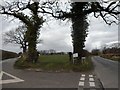
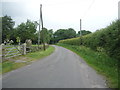
3
Blackden Lane at Goostrey village boundary
Image: © Colin Pyle
Taken: 20 Jun 2014
0.17 miles
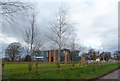
5
View from the hill top, Buckden Lane
This looks like a packing shed, but I might be wrong.
Image: © Christine Johnstone
Taken: 20 May 2012
0.17 miles
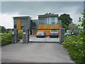
6
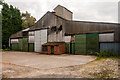
Broomcroft
Agricultural building at Broomcroft.
Image: © Peter McDermott
Taken: 13 Sep 2014
0.17 miles
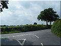
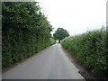
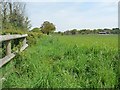
7
A bend in Blackden Lane
Heading north, Blackden Heath.
Image: © JThomas
Taken: 11 Jun 2016
0.20 miles
8
Blackden Lane
Heading north bear Hilltop Farm.
Image: © JThomas
Taken: 11 Jun 2016
0.22 miles
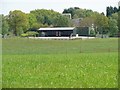
9
Field corner, east of Buckden Lane
With the help of perspective, small trees are almost hiding a large telescope.
Image: © Christine Johnstone
Taken: 20 May 2012
0.22 miles
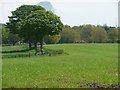
10
Large field near Hill Top Farm
On the east side of Buckden Lane.
Image: © Christine Johnstone
Taken: 20 May 2012
0.22 miles