IMAGES TAKEN NEAR TO
Macclesfield Road, CREWE, CW4 8AN
Introduction
This page details the photographs taken nearby to Macclesfield Road, CW4 8AN by members of the Geograph project.
The Geograph project started in 2005 with the aim of publishing, organising and preserving representative images for every square kilometre of Great Britain, Ireland and the Isle of Man.

There are currently over 7.5m images from over14,400 individuals and you can help contribute to the project by visiting https://www.geograph.org.uk
Image Map
Images are licensed for reuse under creativecommons.org/licenses/by-sa/2.0
Notes
- Clicking on the map will re-center to the selected point.
- The higher the marker number, the further away the image location is from the centre of the postcode.
Image Listing (28 Images Found)
Images are licensed for reuse under creativecommons.org/licenses/by-sa/2.0
Image
Details
Distance
3
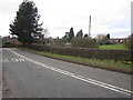
A535 Macclesfield Road near Saltersford Farm, Twemlow Green
Image: © Peter Turner
Taken: 21 Feb 2012
0.05 miles
7
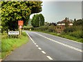
Macclesfield Road approaching Twemlow Green
Image: © David Dixon
Taken: 8 Sep 2014
0.06 miles
8
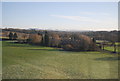
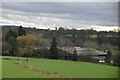
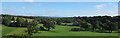
Valley of the River Dane, from the north end of Twemlow Viaduct
In the trees to the left is Twemlow Edge. In the centre, half-obscured, is Saltersford Farm; the name an indication of the way the development of roads in Cheshire was linked to the movement of the salt produced in the area.
Image: © Christopher Hilton
Taken: 2 Jun 2016
0.09 miles
9
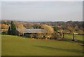
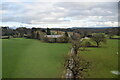
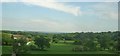
View east from Twemlow Viaduct
The viaduct Image carries the Crewe-Manchester railway line. It gives a good view of the ferticle agricultural land of the middle Dane Valley looking towards Congleton, with The Cloud (hill) in the distance.
Image: © Stephen Craven
Taken: 27 Sep 2015
0.11 miles
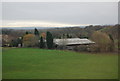
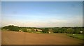
10
Valley of the River Dane, from the north end of Twemlow Viaduct
In the trees to the left is Saltersford Farm; the name an indication of the way the development of roads in Cheshire was linked to the movement of the salt produced in the area.
Image: © Christopher Hilton
Taken: 3 Jun 2016
0.13 miles