IMAGES TAKEN NEAR TO
Macclesfield Road, CREWE, CW4 8AH
Introduction
This page details the photographs taken nearby to Macclesfield Road, CW4 8AH by members of the Geograph project.
The Geograph project started in 2005 with the aim of publishing, organising and preserving representative images for every square kilometre of Great Britain, Ireland and the Isle of Man.

There are currently over 7.5m images from over14,400 individuals and you can help contribute to the project by visiting https://www.geograph.org.uk
Image Map
Images are licensed for reuse under creativecommons.org/licenses/by-sa/2.0
Notes
- Clicking on the map will re-center to the selected point.
- The higher the marker number, the further away the image location is from the centre of the postcode.
Image Listing (13 Images Found)
Images are licensed for reuse under creativecommons.org/licenses/by-sa/2.0
Image
Details
Distance
1
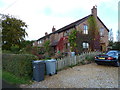
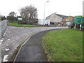
Former council houses converted into expensive residences
Image: © Anthony O'Neil
Taken: 12 Oct 2012
0.01 miles
2
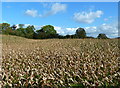
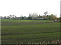
Field of maize near Saltersford Hall, Cheshire
Image: © Anthony O'Neil
Taken: 12 Oct 2012
0.07 miles
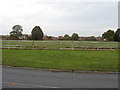
6
Saltersford Stubble
One of the fields belonging to Saltersford Hall farm, lying to stubble.
Image: © Peter Whatley
Taken: 10 Aug 1995
0.14 miles
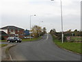
7
Manor Lane, Holmes Chapel
The entrance to Manor Business Park in the foreground. Looks like some regeneration is afoot beyond the entrance road.
Image: © Peter Turner
Taken: 21 Feb 2012
0.15 miles
8
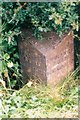
Old Milepost by the A535, Macclesfield Road, Holmes Chapel
Cast iron post by the A535, in parish of Holmes Chapel (Congleton District), roadside, on the verge in hedge, on North West side of road. Cast iron CCC1898, erected by the County Council in the 19th century.
Inscription reads:-
: CHELFORD / 6 MILES / MACCLESFIELD 12½ : : CHESHIRE / 1898 / COUNTY COUNCIL : : MIDDLEWICH / 4 MILES / NORTHWICH 10 :
Maker:-
: W H SMITH & CO / MAKERS / WHITCHURCH :
Milestone Society National ID: CH_NTMF10
Image: © J Higgins
Taken: 1 Jun 2003
0.16 miles
9
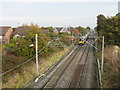
Manchester Train Passes The Chapelmead Estate, Holmes Chapel
Image: © Peter Whatley
Taken: 29 Oct 2009
0.16 miles
10
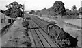
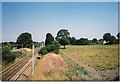
Up local train approaching Holmes Chapel station
View NE from the A535 bridge north of Holmes Chapel station, towards Stockport and Manchester; ex-London & North Western Manchester - Stockport - Crewe main line. The train is the 17.11 Manchester London Road to Crewe, headed by LMS Fowler 4P 2-6-4T No. 42362.
Image: © Ben Brooksbank
Taken: 28 Jul 1951
0.17 miles