IMAGES TAKEN NEAR TO
Holmes Chapel Business Centre, Manor Lane, CREWE, CW4 8AF
Introduction
This page details the photographs taken nearby to Holmes Chapel Business Centre, Manor Lane, CW4 8AF by members of the Geograph project.
The Geograph project started in 2005 with the aim of publishing, organising and preserving representative images for every square kilometre of Great Britain, Ireland and the Isle of Man.

There are currently over 7.5m images from over14,400 individuals and you can help contribute to the project by visiting https://www.geograph.org.uk
Image Map
Images are licensed for reuse under creativecommons.org/licenses/by-sa/2.0
Notes
- Clicking on the map will re-center to the selected point.
- The higher the marker number, the further away the image location is from the centre of the postcode.
Image Listing (37 Images Found)
Images are licensed for reuse under creativecommons.org/licenses/by-sa/2.0
Image
Details
Distance
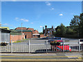
1
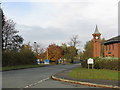
Business Park Clock Tower, Holmes Chapel
Image: © Peter Whatley
Taken: 29 Oct 2009
0.09 miles
3
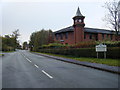
Station Road and Business Park Clock Tower
Image: © Colin Pyle
Taken: 23 Oct 2010
0.10 miles
4
Fads, Holmes Chapel
Wallpaper manufacturer.
Image: © JThomas
Taken: 23 Feb 2013
0.10 miles
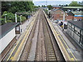
5
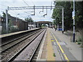
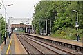
Holmes Chapel railway station
Opened in 1842 by the Manchester & Birmingham Railway on the line from Stockport to Crewe. View south west towards Sandbach and Crewe.
Image: © Nigel Thompson
Taken: 10 Jul 2010
0.11 miles
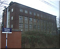
6
Holmes Chapel Station
The station booking office is inconveniently on the lesser-used Crewe platform, a legacy of the original station's construction with goods facilities on this side of the line. The building is a relic of the 1959 electrification: a design very much of its time which has not worn particularly well.
Image: © Peter Whatley
Taken: 29 Oct 2009
0.11 miles
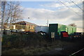
7
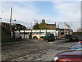
Manor Lane, Holmes Chapel
The entrance to Manor Business Park in the foreground. Looks like some regeneration is afoot beyond the entrance road.
Image: © Peter Turner
Taken: 21 Feb 2012
0.11 miles
8
Platforms, Holmes Chapel railway station
Seen from the northern end of the platforms, the A54 road bridge is at the southern end.
Image: © El Pollock
Taken: 13 Jun 2015
0.11 miles
9
Holmes Chapel station car park
The car park is on the east side of the station, for reasons given by Peter Whatley in his view from the other direction Image The building at the far end, now an Indian takeaway, looks as if it may have been the original station house.
Image: © Stephen Craven
Taken: 27 Sep 2015
0.12 miles
10
Holmes Chapel railway station
Opened in 1842 by the Manchester & Birmingham Railway on the line from Stockport to Crewe. View north east towards Goostrey and Stockport.
Image: © Nigel Thompson
Taken: 10 Jul 2010
0.12 miles