IMAGES TAKEN NEAR TO
Broad Lane, CREWE, CW4 7LT
Introduction
This page details the photographs taken nearby to Broad Lane, CW4 7LT by members of the Geograph project.
The Geograph project started in 2005 with the aim of publishing, organising and preserving representative images for every square kilometre of Great Britain, Ireland and the Isle of Man.

There are currently over 7.5m images from over14,400 individuals and you can help contribute to the project by visiting https://www.geograph.org.uk
Image Map (Loading...)


Getting Data...Please wait
Leaflet Map data © OpenStreetMap
Images are licensed for reuse under creativecommons.org/licenses/by-sa/2.0
Notes
- Clicking on the map will re-center to the selected point.
- The higher the marker number, the further away the image location is from the centre of the postcode.
Image Listing (8 Images Found)
Images are licensed for reuse under creativecommons.org/licenses/by-sa/2.0
Image
Details
Distance
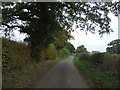
1
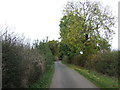
Broad Lane
Heading north east towards Holmes Chapel.
Image: © JThomas
Taken: 29 Oct 2016
0.10 miles
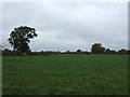
6
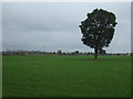
Grazing towards the M6
An Eddie Stobart truck passing.
Image: © JThomas
Taken: 29 Oct 2016
0.18 miles
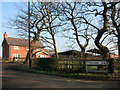
7
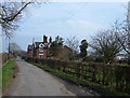
Broadlane Farm, Sproston Green
Situated close to the junction of Broad Lane and Brereton Lane between the towns of Holmes Chapel and Middlewich. View looking west along Broad Lane.
Image: © michael ely
Taken: 24 Mar 2007
0.23 miles
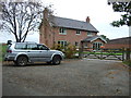
8
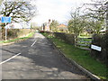
Broad Lane and Farm
Broad is singularly misleading, at least for the lane...
Image: © Peter Whatley
Taken: 1 Mar 2009
0.23 miles