IMAGES TAKEN NEAR TO
Troon Close, CREWE, CW4 7HS
Introduction
This page details the photographs taken nearby to Troon Close, CW4 7HS by members of the Geograph project.
The Geograph project started in 2005 with the aim of publishing, organising and preserving representative images for every square kilometre of Great Britain, Ireland and the Isle of Man.

There are currently over 7.5m images from over14,400 individuals and you can help contribute to the project by visiting https://www.geograph.org.uk
Image Map
Images are licensed for reuse under creativecommons.org/licenses/by-sa/2.0
Notes
- Clicking on the map will re-center to the selected point.
- The higher the marker number, the further away the image location is from the centre of the postcode.
Image Listing (5 Images Found)
Images are licensed for reuse under creativecommons.org/licenses/by-sa/2.0
Image
Details
Distance
1
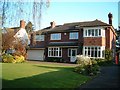
Chester Road. Holmes Chapel in the spring
Image: © Julian Bond
Taken: 15 Apr 2002
0.16 miles
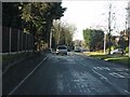
3
A50, London Road approaching railway bridge
Image: © Peter Bond
Taken: 17 Jun 2013
0.24 miles
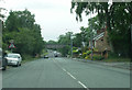
4
London Road, Holmes Chapel
In the foreground a banner advertises the forthcoming Christmas Market to be held on the following Sunday with '40+ stalls (outdoors in the Co-op car park and indoors in the Scout HQ), dancers, school choirs and bands'. Even Father Christmas will be attending.
Image: © Stephen McKay
Taken: 27 Nov 2019
0.24 miles
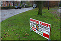
5
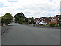
Holmes Chapel - Balmoral Drive at Stirling Court
Just a small part of a very large housing estate on which every element has a Scottish-themed name.
Image: © Peter Whatley
Taken: 15 Jun 2010
0.24 miles