IMAGES TAKEN NEAR TO
Chester Road, CREWE, CW4 7DS
Introduction
This page details the photographs taken nearby to Chester Road, CW4 7DS by members of the Geograph project.
The Geograph project started in 2005 with the aim of publishing, organising and preserving representative images for every square kilometre of Great Britain, Ireland and the Isle of Man.

There are currently over 7.5m images from over14,400 individuals and you can help contribute to the project by visiting https://www.geograph.org.uk
Image Map
Images are licensed for reuse under creativecommons.org/licenses/by-sa/2.0
Notes
- Clicking on the map will re-center to the selected point.
- The higher the marker number, the further away the image location is from the centre of the postcode.
Image Listing (13 Images Found)
Images are licensed for reuse under creativecommons.org/licenses/by-sa/2.0
Image
Details
Distance
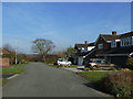
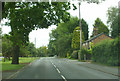
2
Holmes Chapel - Chester Road at Brookfield Drive
Trees, expanses of grass and modern housing are all typical of Holmes Chapel.
Image: © Peter Whatley
Taken: 21 Jan 2011
0.08 miles
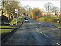
5
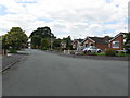
Holmes Chapel - Balmoral Drive at Stirling Court
Just a small part of a very large housing estate on which every element has a Scottish-themed name.
Image: © Peter Whatley
Taken: 15 Jun 2010
0.16 miles
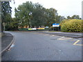
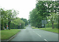
7
B5308 Middlewich Road/Brookfield Drive junction Holmes Chapel
Image: © Peter Turner
Taken: 21 Feb 2012
0.19 miles
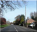
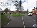
8
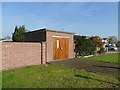
Substation on Moreton Drive
A larger installation than most of those found on housing estates.
Image: © Stephen Craven
Taken: 23 Feb 2019
0.19 miles