IMAGES TAKEN NEAR TO
Aston Lane, CREWE, CW3 9RD
Introduction
This page details the photographs taken nearby to Aston Lane, CW3 9RD by members of the Geograph project.
The Geograph project started in 2005 with the aim of publishing, organising and preserving representative images for every square kilometre of Great Britain, Ireland and the Isle of Man.

There are currently over 7.5m images from over14,400 individuals and you can help contribute to the project by visiting https://www.geograph.org.uk
Image Map
Images are licensed for reuse under creativecommons.org/licenses/by-sa/2.0
Notes
- Clicking on the map will re-center to the selected point.
- The higher the marker number, the further away the image location is from the centre of the postcode.
Image Listing (4 Images Found)
Images are licensed for reuse under creativecommons.org/licenses/by-sa/2.0
Image
Details
Distance
1
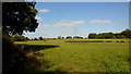
Pasture and woodland, 1
Typical countryside for this northeast corner of Shropshire.
Image: © Jonathan Billinger
Taken: 5 Sep 2018
0.18 miles
2
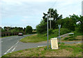
Junction of A525 and Aston Lane.
Badger Lake is behind the wall on the left.
Image: © Neil Lewin
Taken: 25 May 2007
0.19 miles
3
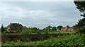
Badger Lake
A nice little dwelling by the A525. The actual lake is behind trees to the left of the house.
Image: © Neil Lewin
Taken: 25 May 2007
0.20 miles
4
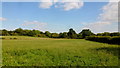
Pasture and woodland, 2
Typical countryside for this northeast corner of Shropshire.
Lea Head Manor and Staffordshire lies beyond the belt of trees.
Image: © Jonathan Billinger
Taken: 5 Sep 2018
0.23 miles