IMAGES TAKEN NEAR TO
Heath Row, CREWE, CW3 9LN
Introduction
This page details the photographs taken nearby to Heath Row, CW3 9LN by members of the Geograph project.
The Geograph project started in 2005 with the aim of publishing, organising and preserving representative images for every square kilometre of Great Britain, Ireland and the Isle of Man.

There are currently over 7.5m images from over14,400 individuals and you can help contribute to the project by visiting https://www.geograph.org.uk
Image Map (Loading...)


Getting Data...Please wait
Leaflet Map data © OpenStreetMap
Images are licensed for reuse under creativecommons.org/licenses/by-sa/2.0
Notes
- Clicking on the map will re-center to the selected point.
- The higher the marker number, the further away the image location is from the centre of the postcode.
Image Listing (18 Images Found)
Images are licensed for reuse under creativecommons.org/licenses/by-sa/2.0
Image
Details
Distance
1

Footpath in Madeley Heath
This very short footpath (120 metres) runs between Wharf Terrace and Leycett Lane in Madeley Heath. On the right is the back of the Crewe Arms Hotel, the front of which can be seen in https://www.geograph.org.uk/photo/5717668
Image: © Jonathan Hutchins
Taken: 25 Mar 2018
0.07 miles

3

Crewe Arms Hotel, Madeley
Website: http://thecrewearmshotelmadeley.co.uk/
Image: © Jonathan Hutchins
Taken: 25 Mar 2018
0.08 miles
4
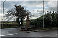
Men Of Madeley Heath, War Memorial
Rededicated : C 18 Nov.1949
Unveiled : 27 August 1921
Square sided tapered plinth surmounted by a sculpted figure of a soldier in service dress with rifle and cap. The memorial is enclosed by wrought iron railings. Dedicatory inscriptions incised: WW1 at front, WW2 on one side.
http://www.iwm.org.uk/memorials/item/memorial/61497
Image: © Brian Deegan
Taken: 3 Dec 2017
0.09 miles

6
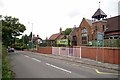
Meadows School Madeley Heath
The school is in Newcastle Road
Image: © Glyn Baker
Taken: 29 Aug 2014
0.12 miles
7

Road junction with mining memorial
Image: © Jonathan Hutchins
Taken: 25 Mar 2018
0.12 miles
8
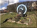
Mining memorial at Madeley
This is sited at the junction of Leycett Lane and the main road.
Transcription:
In Memory
of the 63 miners who lost their
lives in the Leycett pit disaster
January 21st 1880.
Also all those who lost their lives
in the mining industry.
May they rest in peace.
Image: © Jonathan Hutchins
Taken: 25 Mar 2018
0.13 miles
9

Course of the Hazeley Brook
The brook's course across the field is marked by the line of trees in the middle distance.
Image: © Jonathan Hutchins
Taken: 25 Mar 2018
0.15 miles
10
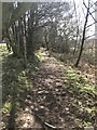
Public footpath south of Madeley Heath
This footpath runs along the trackbed of Thomas Firmstone's railway. He was a local industrialist who constructed his own three and a half mile railway from his leased mines at Leycett through Madeley Heath to the main line station at Madeley in 1838.
On the left is the tile factory site of Marley Eternit https://www.geograph.org.uk/photo/5717690
Image: © Jonathan Hutchins
Taken: 25 Mar 2018
0.16 miles