IMAGES TAKEN NEAR TO
Main Road, CREWE, CW3 9DQ
Introduction
This page details the photographs taken nearby to Main Road, CW3 9DQ by members of the Geograph project.
The Geograph project started in 2005 with the aim of publishing, organising and preserving representative images for every square kilometre of Great Britain, Ireland and the Isle of Man.

There are currently over 7.5m images from over14,400 individuals and you can help contribute to the project by visiting https://www.geograph.org.uk
Image Map (Loading...)


Getting Data...Please wait
Leaflet Map data © OpenStreetMap
Images are licensed for reuse under creativecommons.org/licenses/by-sa/2.0
Notes
- Clicking on the map will re-center to the selected point.
- The higher the marker number, the further away the image location is from the centre of the postcode.
Image Listing (4 Images Found)
Images are licensed for reuse under creativecommons.org/licenses/by-sa/2.0
Image
Details
Distance
1
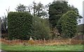
Ruined Building near Bowseywood Farm
The ruined building was fenced off so I thought I better not explore it
Image: © Ian Bottomley
Taken: 27 Oct 2007
0.06 miles
2
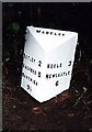
Old Milepost by the A531, west of Madeley Heath
Cast iron post by the A531, in parish of Madeley (Newcastle Under Lyme District), East of Bowseywood Farm drive, in hedge, on South side of road. Lathe iron casting, erected by the County Council in the 19th/20th century.
Inscription reads:-
: BETLEY 2 / BASFORD 5 / NANTWICH / 9½ : : MADELEY : : KEELE 3 / NEWCASTLE / 6 :
Maker:-
: Chas. Lathe, Tipton. :
Grade II listed.
List Entry Number: 1027998 https://historicengland.org.uk/listing/the-list/list-entry/1027998
Milestone Society National ID: ST_NCNW06
Image: © J Higgins
Taken: 1 Jan 2001
0.18 miles
4
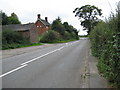
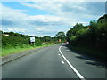
Looking west along the A531
Buildings beside the main road. Wrinehill is just around the corner.
Image: © Peter Fleming
Taken: 8 Sep 2007
0.19 miles