IMAGES TAKEN NEAR TO
Den Lane, CREWE, CW3 9BU
Introduction
This page details the photographs taken nearby to Den Lane, CW3 9BU by members of the Geograph project.
The Geograph project started in 2005 with the aim of publishing, organising and preserving representative images for every square kilometre of Great Britain, Ireland and the Isle of Man.

There are currently over 7.5m images from over14,400 individuals and you can help contribute to the project by visiting https://www.geograph.org.uk
Image Map (Loading...)


Getting Data...Please wait
Leaflet Map data © OpenStreetMap
Images are licensed for reuse under creativecommons.org/licenses/by-sa/2.0
Notes
- Clicking on the map will re-center to the selected point.
- The higher the marker number, the further away the image location is from the centre of the postcode.
Image Listing (4 Images Found)
Images are licensed for reuse under creativecommons.org/licenses/by-sa/2.0
Image
Details
Distance
2
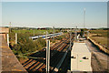
Den Bridge
View south from Den Bridge of the West Coast Main Line between Crewe and Stafford.
Image: © Peter Styles
Taken: 8 Sep 2006
0.20 miles
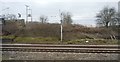
4
Site of Betley Road Station
View SE on Crewe - Stafford, Birmingham and London trunk route (West Coast Main Line). Station closed to passengers 1/10/45, to goods 13/3/50.
Image: © Ben Brooksbank
Taken: 8 Oct 1961
0.24 miles