IMAGES TAKEN NEAR TO
Joseph Major Close, CW2 5XR
Introduction
This page details the photographs taken nearby to Joseph Major Close, CW2 5XR by members of the Geograph project.
The Geograph project started in 2005 with the aim of publishing, organising and preserving representative images for every square kilometre of Great Britain, Ireland and the Isle of Man.

There are currently over 7.5m images from over14,400 individuals and you can help contribute to the project by visiting https://www.geograph.org.uk
Image Map
Images are licensed for reuse under creativecommons.org/licenses/by-sa/2.0
Notes
- Clicking on the map will re-center to the selected point.
- The higher the marker number, the further away the image location is from the centre of the postcode.
Image Listing (5 Images Found)
Images are licensed for reuse under creativecommons.org/licenses/by-sa/2.0
Image
Details
Distance
1
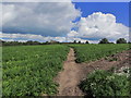
S Cheshire Way crossing carrot crop, SW of Weston near Crewe
Image: © Colin Park
Taken: 27 Aug 2015
0.13 miles
2
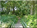
Crossing Basford Brook
Weston/Basford parish boundary. Crossing Basford Brook.
Image: © Mike Harris
Taken: 12 Jul 2006
0.16 miles
3
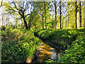
Basford Brook in Burrow Coppice
Taken on the South Cheshire Way
Image: © Scott Robinson
Taken: 14 May 2020
0.18 miles
4
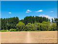
Field Footpath
Crossing an arable field heading towards woodland on the outskirts of Weston from Casey Bridge.
Image: © Scott Robinson
Taken: 14 May 2020
0.19 miles
5
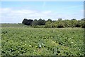
Potato field, Basford
Basford. On the South Cheshire Way; potato field near Burrow Coppice.
Image: © Mike Harris
Taken: 12 Jul 2006
0.23 miles