IMAGES TAKEN NEAR TO
Balterley Green Road, CREWE, CW2 5QQ
Introduction
This page details the photographs taken nearby to Balterley Green Road, CW2 5QQ by members of the Geograph project.
The Geograph project started in 2005 with the aim of publishing, organising and preserving representative images for every square kilometre of Great Britain, Ireland and the Isle of Man.

There are currently over 7.5m images from over14,400 individuals and you can help contribute to the project by visiting https://www.geograph.org.uk
Image Map
Images are licensed for reuse under creativecommons.org/licenses/by-sa/2.0
Notes
- Clicking on the map will re-center to the selected point.
- The higher the marker number, the further away the image location is from the centre of the postcode.
Image Listing (9 Images Found)
Images are licensed for reuse under creativecommons.org/licenses/by-sa/2.0
Image
Details
Distance
1
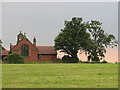
All Saints church, Balterley
taken from the Old Smithy looking west
Image: © Martin Connolly
Taken: 5 Jul 2006
0.13 miles
2
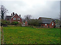
Bell Farm
Situated next to the B5500 at Balterley.
Image: © Jonathan Billinger
Taken: 2 Jan 2008
0.15 miles
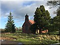
3
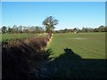
View To The Rear Of Balterley Church
The shadow of the church bell turret can be seen.
Image: © Geoff Pick
Taken: 30 Jan 2010
0.17 miles
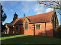
4
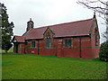
All Saints church, Balterley
Constructed of brick and red sandstone, standing north of the B5500.
Image: © Jonathan Billinger
Taken: 2 Jan 2008
0.17 miles
5
Balterley: All Saints' Church
Wikipedia entry for the church: https://en.wikipedia.org/wiki/All_Saints_Church,_Balterley
Image: © Jonathan Hutchins
Taken: 23 Dec 2015
0.19 miles
6
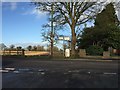
Balterley: junction of B5500 and Back Lane
Behind the wall and tree on the right is the church http://www.geograph.org.uk/photo/4772307
Image: © Jonathan Hutchins
Taken: 23 Dec 2015
0.20 miles
7

Old Milepost by the B5500, Balterley Parish
Cast iron post by the B5500, in parish of BALTERLEY (NEWCASTLE UNDER LYME District), by chapel, against wall, on North side of road. Dudley iron casting, erected by the Newcastle under Lyme & Nantwich turnpike trust in the 19th century.
Inscription reads:-
: MILES / CHESTERTON 5 / AUDLEY 2¾ : : TOWNSHIP / OF / BALTERLEY : : MILES / GORSTY HILL 1 / BASFORD 2¾ / NANTWICH 10¼ :
Grade II listed. List Entry Number: 1374408
https://historicengland.org.uk/listing/the-list/list-entry/1374408
Milestone Society National ID: ST_NWCN07.
Image: © J Higgins
Taken: Unknown
0.20 miles
8
Balterley: All Saints' Church
Wikipedia entry for the church: https://en.wikipedia.org/wiki/All_Saints_Church,_Balterley
Image: © Jonathan Hutchins
Taken: 23 Dec 2015
0.20 miles
9
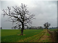
Oak in a field
View north of All Saints church, Balterley.
Image: © Jonathan Billinger
Taken: 2 Jan 2008
0.24 miles