IMAGES TAKEN NEAR TO
Deans Lane, CREWE, CW2 5PD
Introduction
This page details the photographs taken nearby to Deans Lane, CW2 5PD by members of the Geograph project.
The Geograph project started in 2005 with the aim of publishing, organising and preserving representative images for every square kilometre of Great Britain, Ireland and the Isle of Man.

There are currently over 7.5m images from over14,400 individuals and you can help contribute to the project by visiting https://www.geograph.org.uk
Image Map
Images are licensed for reuse under creativecommons.org/licenses/by-sa/2.0
Notes
- Clicking on the map will re-center to the selected point.
- The higher the marker number, the further away the image location is from the centre of the postcode.
Image Listing (10 Images Found)
Images are licensed for reuse under creativecommons.org/licenses/by-sa/2.0
Image
Details
Distance
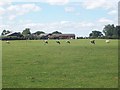
1
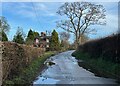
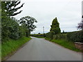
Lane to Barthomley
The lane from Englesea Brook to Barthomley is part of National Cycle Network route 551 (between Newcastle-under-Lyme and Winsford) and also the Two Saints' Way (between Chester and Lichfield).
Image: © Jonathan Hutchins
Taken: 4 Jan 2024
0.13 miles
2
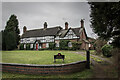
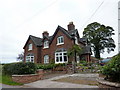
The Old Farm House, Barthomley
Built late 17th Century.
Image: © Brian Deegan
Taken: 22 Jan 2022
0.14 miles
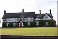
4
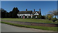
A pair of semis, Barthomley
On the right Primrose Cottage and on the left Sycamore Cottage
Image: © Alexander P Kapp
Taken: 13 Sep 2010
0.15 miles
7
Lane to Barthomley
The lane from Englesea Brook to Barthomley is part of National Cycle Network route 551 (between Newcastle-under-Lyme and Winsford) and also the Two Saints' Way (between Chester and Lichfield).
Image: © Jonathan Hutchins
Taken: 4 Jan 2024
0.18 miles
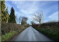
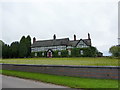
8
Road near Primrose Cottage, Barthomley
Image: © Alexander P Kapp
Taken: 13 Sep 2010
0.18 miles
9
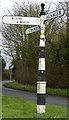
Old Direction Sign - Signpost west of Barthomley
Pawn finial - 3 arms; Cheshire CC post in the parish of Barthomley (Crewe And Nantwich District), at the eastern corner of the triangular green at the junction of Barthomley Road and Radway Green Road.
Surveyed
Milestone Society National ID: CH_SJ7652A
Image: © M Bardell
Taken: 7 Apr 2016
0.20 miles