IMAGES TAKEN NEAR TO
Mill Lane, CREWE, CW2 5NL
Introduction
This page details the photographs taken nearby to Mill Lane, CW2 5NL by members of the Geograph project.
The Geograph project started in 2005 with the aim of publishing, organising and preserving representative images for every square kilometre of Great Britain, Ireland and the Isle of Man.

There are currently over 7.5m images from over14,400 individuals and you can help contribute to the project by visiting https://www.geograph.org.uk
Image Map
Images are licensed for reuse under creativecommons.org/licenses/by-sa/2.0
Notes
- Clicking on the map will re-center to the selected point.
- The higher the marker number, the further away the image location is from the centre of the postcode.
Image Listing (5 Images Found)
Images are licensed for reuse under creativecommons.org/licenses/by-sa/2.0
Image
Details
Distance
2
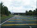
Crewe Green Link Road (South): south end
The Crewe Green Link Road (South) scheme (CGLRS) is a 1.1km dual carriageway link running north–south between the Weston Gate roundabout on the A5020 Weston Road and the A500 Hough–Shavington Bypass.
For more details see http://www.cheshireeasthighways.org/Roadworks-Centre/Major-Projects/Crewe-Green.aspx
Image: © Jonathan Hutchins
Taken: 5 Apr 2015
0.18 miles
4
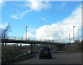
Mill Lane bridge over A500
The bridge gives access to Crotia Mill Farm; the lane was diverted when the A500 was built. There is also emergency access from the bridge to the A5020
Image: © David Smith
Taken: 3 Mar 2019
0.19 miles
5
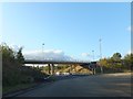
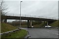
Bridge over A500 and partial roundabout
The roundabout currently has no exits except the A500 in and out and the bridge is for a footpath and farm traffic
Image: © David Smith
Taken: 19 Oct 2011
0.20 miles