
IMAGES TAKEN NEAR TO
Main Road, CREWE, CW2 5LD
Introduction
This page details the photographs taken nearby to Main Road, CW2 5LD by members of the Geograph project.
The Geograph project started in 2005 with the aim of publishing, organising and preserving representative images for every square kilometre of Great Britain, Ireland and the Isle of Man.

There are currently over 7.5m images from over14,400 individuals and you can help contribute to the project by visiting https://www.geograph.org.uk
Image Map
Images are licensed for reuse under creativecommons.org/licenses/by-sa/2.0
Notes
- Clicking on the map will re-center to the selected point.
- The higher the marker number, the further away the image location is from the centre of the postcode.
Image Listing (22 Images Found)
Images are licensed for reuse under creativecommons.org/licenses/by-sa/2.0
Image
Details
Distance
1
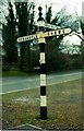
Old Direction Sign - Signpost by Main Road, Weston village
Pawn finial - 3 arms; Cheshire CCC octagonal by the UC road, in parish of Weston (Crewe and Nantwich District), Whites Lane junction with Main Road in Weston village.
Surveyed
Milestone Society National ID: CH_SJ7352
Image: © Milestone Society
Taken: Unknown
0.04 miles
2

New A500 Dual Carriageway
Runs from near Nantwich to the M6 AT J16. Taken 14th October at 10:42.
Image: © David Crocker
Taken: 14 Oct 2005
0.09 miles
3
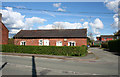
Former smithy, Main Road, Weston
This single-storey building claims to be the former village smithy. The adjacent street (right) is Smithy Lane
Image: © Espresso Addict
Taken: 1 May 2008
0.13 miles
4

South Cheshire Way, Weston
Weston. South Cheshire Way, beyond Smithy Lane. View of new A500 bridge.
Image: © Mike Harris
Taken: 12 Jul 2006
0.13 miles
5
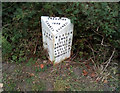
Milepost, North of Weston
Cast iron milepost in Main Street, on rise to bridge over A500
Cheshire County Council 1898 / Crewe 2 / Weston ½ / Betley 3½ / Wrinehill 4½ / Audley 5½ / Keele 8 / Newcastle 11
Milestone Society National ID: CH_CWNC02
Image: © Graham Dyde
Taken: 8 Aug 2020
0.13 miles
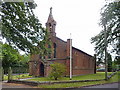
8
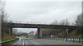
Bridge over A500 north of Weston
The road runs in a shallow cutting
Image: © David Smith
Taken: 3 Mar 2019
0.18 miles
9

Minor road running north from Weston crossing A500
Image: © David Smith
Taken: 19 Oct 2011
0.18 miles
10
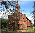
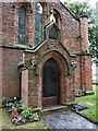
Church of All Saints, Weston
Founded in 1838, the Church of All Saints became a parish church in 1841. It is listed at grade II. For more information, see: http://www.imagesofengland.org.uk/details/default.aspx?id=57134
Image: © Espresso Addict
Taken: 1 May 2008
0.19 miles