IMAGES TAKEN NEAR TO
Savoy Road, CREWE, CW1 6NF
Introduction
This page details the photographs taken nearby to Savoy Road, CW1 6NF by members of the Geograph project.
The Geograph project started in 2005 with the aim of publishing, organising and preserving representative images for every square kilometre of Great Britain, Ireland and the Isle of Man.

There are currently over 7.5m images from over14,400 individuals and you can help contribute to the project by visiting https://www.geograph.org.uk
Image Map
Images are licensed for reuse under creativecommons.org/licenses/by-sa/2.0
Notes
- Clicking on the map will re-center to the selected point.
- The higher the marker number, the further away the image location is from the centre of the postcode.
Image Listing (18 Images Found)
Images are licensed for reuse under creativecommons.org/licenses/by-sa/2.0
Image
Details
Distance
1
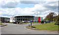
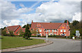
Savoy Road industrial/retail park
Small recently developed industrial/retail park on Savoy Road (off Weston Road) on the eastern edge of Crewe
Image: © Espresso Addict
Taken: 1 May 2008
0.05 miles
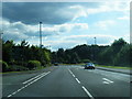
2
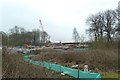
Crewe Green Link Road (South): north end
The Crewe Green Link Road (South) scheme (CGLRS) is a 1.1km dual carriageway link running north–south between the Weston Gate roundabout on the A5020 Weston Road and the A500 Hough–Shavington Bypass.
For more details see http://www.cheshireeasthighways.org/Roadworks-Centre/Major-Projects/Crewe-Green.aspx
Image: © Jonathan Hutchins
Taken: 5 Apr 2015
0.06 miles
3
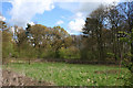
Woodland by Weston Road
Strip of woodland between Weston Road and the Crewe-Alsager railway line, just outside the boundary of Crewe. View from the roundabout at the junction of Weston Road and the A5020
Image: © Espresso Addict
Taken: 1 May 2008
0.09 miles
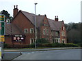
5
Rookery Wood public house, Weston Road
Public house which opened in 1997, located on the junction between Weston Road (A532) and the recently built A5020 on the eastern edge of Crewe. It is named for the woodland behind it, formerly part of the Crewe Hall parkland
Image: © Espresso Addict
Taken: 1 May 2008
0.11 miles
9
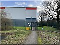
Security turnstile and fencing on industrial estate
Image: © Jonathan Hutchins
Taken: 29 Jan 2023
0.17 miles
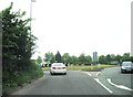
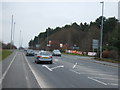
10
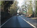
A5020 on the outskirts of Crewe
The road from the M6 is about to enter Crewe's outskirts, heralded by the roundabout ahead.
Image: © Peter Whatley
Taken: 21 Jan 2011
0.17 miles