IMAGES TAKEN NEAR TO
Hungerford Road, CREWE, CW1 6HD
Introduction
This page details the photographs taken nearby to Hungerford Road, CW1 6HD by members of the Geograph project.
The Geograph project started in 2005 with the aim of publishing, organising and preserving representative images for every square kilometre of Great Britain, Ireland and the Isle of Man.

There are currently over 7.5m images from over14,400 individuals and you can help contribute to the project by visiting https://www.geograph.org.uk
Image Map
Images are licensed for reuse under creativecommons.org/licenses/by-sa/2.0
Notes
- Clicking on the map will re-center to the selected point.
- The higher the marker number, the further away the image location is from the centre of the postcode.
Image Listing (2 Images Found)
Images are licensed for reuse under creativecommons.org/licenses/by-sa/2.0
Image
Details
Distance
1
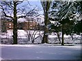
Harley Hall - MMU Cheshire
Students residence block built about 1960
Image: © Mike Grose
Taken: 2 Mar 2006
0.12 miles
2
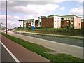
Booth Hall - MMU Cheshire
800 bed hall of residence opened in September 2005
Image: © Mike Grose
Taken: 4 Apr 2006
0.21 miles