IMAGES TAKEN NEAR TO
Slaughter Hill, CREWE, CW1 5UR
Introduction
This page details the photographs taken nearby to Slaughter Hill, CW1 5UR by members of the Geograph project.
The Geograph project started in 2005 with the aim of publishing, organising and preserving representative images for every square kilometre of Great Britain, Ireland and the Isle of Man.

There are currently over 7.5m images from over14,400 individuals and you can help contribute to the project by visiting https://www.geograph.org.uk
Image Map
Images are licensed for reuse under creativecommons.org/licenses/by-sa/2.0
Notes
- Clicking on the map will re-center to the selected point.
- The higher the marker number, the further away the image location is from the centre of the postcode.
Image Listing (10 Images Found)
Images are licensed for reuse under creativecommons.org/licenses/by-sa/2.0
Image
Details
Distance
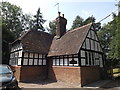
4
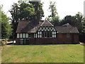
Bottle Lodge
This view is from the garden showing the rear of the building.
Image: © Garry Lavender-Rimmer
Taken: 5 Aug 2018
0.20 miles
5
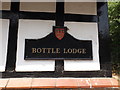
Bottle Lodge
Name plate showing the Duchy of Lancaster motif
Image: © Garry Lavender-Rimmer
Taken: 5 Aug 2018
0.20 miles
6
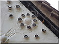
Bottle Lodge
This view shows where the lodge gets its name from. Each of the circles shown are actually the top of a wine bottle.
Image: © Garry Lavender-Rimmer
Taken: 5 Aug 2018
0.20 miles
7
Bottle Lodge
Bottle Lodge is part of the Duchy of Lancasters estate of which Crewe hall is part.
The Duchy is part of Her Majesty the Queen's private property.
Image: © Garry Lavender-Rimmer
Taken: 5 Aug 2018
0.20 miles
8
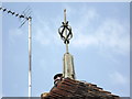
Bottle Lodge
Roof feature at Bottle lodge.
Image: © Garry Lavender-Rimmer
Taken: 5 Aug 2018
0.20 miles