IMAGES TAKEN NEAR TO
Barthomley Road, CREWE, CW1 5UH
Introduction
This page details the photographs taken nearby to Barthomley Road, CW1 5UH by members of the Geograph project.
The Geograph project started in 2005 with the aim of publishing, organising and preserving representative images for every square kilometre of Great Britain, Ireland and the Isle of Man.

There are currently over 7.5m images from over14,400 individuals and you can help contribute to the project by visiting https://www.geograph.org.uk
Image Map (Loading...)


Getting Data...Please wait
Leaflet Map data © OpenStreetMap
Images are licensed for reuse under creativecommons.org/licenses/by-sa/2.0
Notes
- Clicking on the map will re-center to the selected point.
- The higher the marker number, the further away the image location is from the centre of the postcode.
Image Listing (7 Images Found)
Images are licensed for reuse under creativecommons.org/licenses/by-sa/2.0
Image
Details
Distance
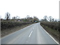
1
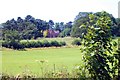
Englesea House from Barthomley Road
Crewe Green. South Cheshire Way, Barthomley Road near Gravel Farm. View towards Englesea House.
Image: © Mike Harris
Taken: 12 Jul 2006
0.03 miles
3
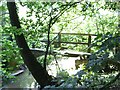
Footbridge over Valley Brook
This bridge forms part of the South Cheshire Way where it passes over Valley Brook.
Image: © Steve Lewin
Taken: 5 Jul 2006
0.20 miles
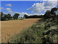
4
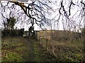
Footpath onto Barthomley Road near Crewe
This is footpath Crewe Green FP 2, which is also part of two designated routes, the Crewe and Nantwich Circular Walk and the South Cheshire Way. The railway bridge crosses the Alsager-Crewe line, which is single track at this point.
Image: © Jonathan Hutchins
Taken: 10 Jan 2016
0.20 miles
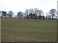
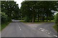
7
On S Cheshire Way, S of Gravel Farm, Crewe Green
Image: © Colin Park
Taken: 27 Aug 2015
0.23 miles