IMAGES TAKEN NEAR TO
Crewe Road, CREWE, CW1 5NR
Introduction
This page details the photographs taken nearby to Crewe Road, CW1 5NR by members of the Geograph project.
The Geograph project started in 2005 with the aim of publishing, organising and preserving representative images for every square kilometre of Great Britain, Ireland and the Isle of Man.

There are currently over 7.5m images from over14,400 individuals and you can help contribute to the project by visiting https://www.geograph.org.uk
Image Map
Images are licensed for reuse under creativecommons.org/licenses/by-sa/2.0
Notes
- Clicking on the map will re-center to the selected point.
- The higher the marker number, the further away the image location is from the centre of the postcode.
Image Listing (44 Images Found)
Images are licensed for reuse under creativecommons.org/licenses/by-sa/2.0
Image
Details
Distance

2
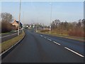
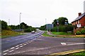
A5020 (University Way) approaching Crewe Green roundabout
Image: © Peter Whatley
Taken: 21 Jan 2011
0.07 miles
3
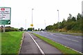
University Way (A5020), Crewe, Cheshire
University Way forms part of the A5020 road. It is seen here heading north for a roundabout where it meets the A534, B5077 and Sydney Road.
Image: © P L Chadwick
Taken: 10 Sep 2016
0.08 miles
6
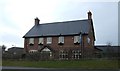
Junction of University Way and Beswick Drive, Crewe, Cheshire
University Way is part of the A5020 road. Beswick Drive is on the right. The building on the corner is the Duke of Gloucester public house.
Image: © P L Chadwick
Taken: 10 Sep 2016
0.10 miles
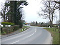
7
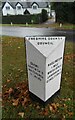
Old Milepost by the B5077 in Crewe Green
Cast iron post by the B5077 (was A534), in parish of CREWE GREEN (CREWE AND NANTWICH District), corner of Narrow Lane, near Church Road junction in Crewe Green, on open grass, on East side of road. Cast iron (CCCX?), erected by the County Council in the 20th century.
Inscription reads:- : CREWE 1 / NANTWICH 5 / WHITCHURCH / 16 MILES : : HASLINGTON / 1 MILE / WHEELOCK 3½ / SANDBACH 5 / CONGLETON 12 : : CHESHIRE / COUNTY COUNCIL :
Listed.
Milestone Society National ID: CH_NWCO05.
Image: © Ian Scrimgeour
Taken: 3 Oct 2013
0.10 miles
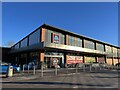
10
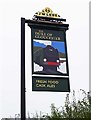
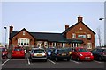
The Duke of Gloucester (2) - sign, University Way, Crewe, Cheshire
This public house is named after the former British Railways steam engine no. 71000 "The Duke of Gloucester", which was built in Crewe in 1954. The engine survives, having been rescued from a scrap yard and undergone major restoration work. It is owned by a preservation trust.
Other photographs, see:- Image
Image: © P L Chadwick
Taken: 10 Sep 2016
0.11 miles