IMAGES TAKEN NEAR TO
School Crescent, CREWE, CW1 5HA
Introduction
This page details the photographs taken nearby to School Crescent, CW1 5HA by members of the Geograph project.
The Geograph project started in 2005 with the aim of publishing, organising and preserving representative images for every square kilometre of Great Britain, Ireland and the Isle of Man.

There are currently over 7.5m images from over14,400 individuals and you can help contribute to the project by visiting https://www.geograph.org.uk
Image Map
Images are licensed for reuse under creativecommons.org/licenses/by-sa/2.0
Notes
- Clicking on the map will re-center to the selected point.
- The higher the marker number, the further away the image location is from the centre of the postcode.
Image Listing (20 Images Found)
Images are licensed for reuse under creativecommons.org/licenses/by-sa/2.0
Image
Details
Distance
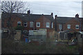
2
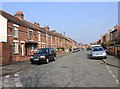
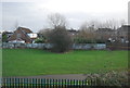
Hungerford Avenue
Looking north up Hungerford Avenue from Bulkeley Street.
Image: © David P Howard
Taken: 22 Mar 2012
0.15 miles
5
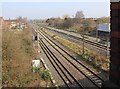
View from Manchester Bridge
Looking NE along the railway lines from the A532 Manchester Bridge.
Image: © David P Howard
Taken: 22 Mar 2012
0.17 miles
10
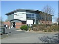
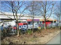
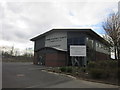
Crewe Veterinary Hospital
Modern veterinary hospital opened in 2011 on Macon Way by Nantwich Veterinary Group.
Image: © John M
Taken: 20 Apr 2016
0.18 miles