IMAGES TAKEN NEAR TO
Cloverfields, CREWE, CW1 5AL
Introduction
This page details the photographs taken nearby to Cloverfields, CW1 5AL by members of the Geograph project.
The Geograph project started in 2005 with the aim of publishing, organising and preserving representative images for every square kilometre of Great Britain, Ireland and the Isle of Man.

There are currently over 7.5m images from over14,400 individuals and you can help contribute to the project by visiting https://www.geograph.org.uk
Image Map (Loading...)


Getting Data...Please wait
Leaflet Map data © OpenStreetMap
Images are licensed for reuse under creativecommons.org/licenses/by-sa/2.0
Notes
- Clicking on the map will re-center to the selected point.
- The higher the marker number, the further away the image location is from the centre of the postcode.
Image Listing (4 Images Found)
Images are licensed for reuse under creativecommons.org/licenses/by-sa/2.0
Image
Details
Distance
1
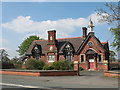
Former village school, Crewe Green
The sign on the door shows that this is now a dance studio.
Image: © Stephen Craven
Taken: 18 Apr 2009
0.21 miles
2
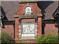
Time rewarding industry and punishing sloth
An unusual bas-relief image on a former primary school Image
Image: © Stephen Craven
Taken: 18 Apr 2009
0.21 miles
3
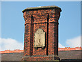
Sundial, Crewe Green school
The sundial on the chimney of Image gives the date of construction as 1882, and the wording is "use well thy time".
Image: © Stephen Craven
Taken: 18 Apr 2009
0.21 miles
4
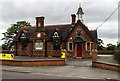
Crewe Green
Building at Crewe Green.
Image: © Peter McDermott
Taken: 28 Aug 2017
0.21 miles