IMAGES TAKEN NEAR TO
Thornfields, CREWE, CW1 4TY
Introduction
This page details the photographs taken nearby to Thornfields, CW1 4TY by members of the Geograph project.
The Geograph project started in 2005 with the aim of publishing, organising and preserving representative images for every square kilometre of Great Britain, Ireland and the Isle of Man.

There are currently over 7.5m images from over14,400 individuals and you can help contribute to the project by visiting https://www.geograph.org.uk
Image Map
Images are licensed for reuse under creativecommons.org/licenses/by-sa/2.0
Notes
- Clicking on the map will re-center to the selected point.
- The higher the marker number, the further away the image location is from the centre of the postcode.
Image Listing (6 Images Found)
Images are licensed for reuse under creativecommons.org/licenses/by-sa/2.0
Image
Details
Distance
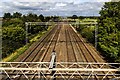
3
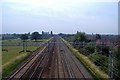
West Coast main line north of Crewe
Crewe. View along the West Coast Main line towards Crewe Station from the footbridge carrying the Crewe & Nantwich Circular Walk just east of Barrows Green.
Image: © Mike Harris
Taken: 5 Jul 2006
0.20 miles
4
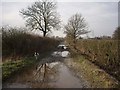
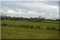
Part of the Crewe and Nantwich Circular Walk
This track was waterlogged, like most of this area
Image: © Ian Bottomley
Taken: 9 Feb 2008
0.22 miles
5
Railway
Railway seen from Moss Bridge.
Image: © Peter McDermott
Taken: 28 Aug 2017
0.25 miles