IMAGES TAKEN NEAR TO
John Maddock Drive, CREWE, CW1 4SR
Introduction
This page details the photographs taken nearby to John Maddock Drive, CW1 4SR by members of the Geograph project.
The Geograph project started in 2005 with the aim of publishing, organising and preserving representative images for every square kilometre of Great Britain, Ireland and the Isle of Man.

There are currently over 7.5m images from over14,400 individuals and you can help contribute to the project by visiting https://www.geograph.org.uk
Image Map
Images are licensed for reuse under creativecommons.org/licenses/by-sa/2.0
Notes
- Clicking on the map will re-center to the selected point.
- The higher the marker number, the further away the image location is from the centre of the postcode.
Image Listing (10 Images Found)
Images are licensed for reuse under creativecommons.org/licenses/by-sa/2.0
Image
Details
Distance
3
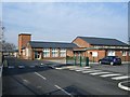
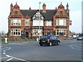
Voyager MPV facility near Crewe
Voyager is a specialist vehicle manufacturer, including taxis, wheelchair accessible vehicles and conversions.
Image: © Jonathan Hutchins
Taken: 30 Jan 2016
0.19 miles
6
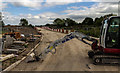
Coppenhall
New development at Coppenhall in Crewe.
Image: © Peter McDermott
Taken: 28 Aug 2017
0.22 miles
7
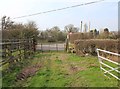
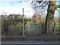
Footpath from Maw Green approaches Stoneley Road
The footpath approaches Stoneley Road near Stoneley Farm.
Image: © David P Howard
Taken: 22 Mar 2012
0.23 miles
9
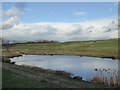
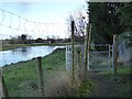
Maw Green Tip run-off pool
The tip lies behind and to the right.
Image: © Jonathan Hutchins
Taken: 30 Jan 2016
0.24 miles
10
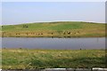
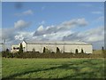
Reclaimed landfill site and lake
View ENE from the footpath from Maw Green towards Brook Farm. The footpath skirts the edge of a large landfill site that has been reclaimed and landscaped. The many small pipes protruding from the ground are vents or sampling points to monitor the buried waste.
Image: © David P Howard
Taken: 22 Mar 2012
0.25 miles