IMAGES TAKEN NEAR TO
Eardswick Lane, CREWE, CW1 4RH
Introduction
This page details the photographs taken nearby to Eardswick Lane, CW1 4RH by members of the Geograph project.
The Geograph project started in 2005 with the aim of publishing, organising and preserving representative images for every square kilometre of Great Britain, Ireland and the Isle of Man.

There are currently over 7.5m images from over14,400 individuals and you can help contribute to the project by visiting https://www.geograph.org.uk
Image Map
Images are licensed for reuse under creativecommons.org/licenses/by-sa/2.0
Notes
- Clicking on the map will re-center to the selected point.
- The higher the marker number, the further away the image location is from the centre of the postcode.
Image Listing (3 Images Found)
Images are licensed for reuse under creativecommons.org/licenses/by-sa/2.0
Image
Details
Distance
1

Minshull United Reformed Church, Minshull Vernon
Minshull United Reformed Church is at the junction of Eardswick Lane, Cross Lane and Brookhouse Lane; this view is from Eardswick Lane. The grade-II-listed church was built in 1809-10 and altered c. 1880; it was originally a Congregational Chapel. See also Image For more information, see http://www.imagesofengland.org.uk/details/default.aspx?id=56627
Image: © Espresso Addict
Taken: 5 Mar 2009
0.01 miles
2
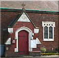
Minshull United Reformed Church: detail
Porch and window of Minshull United Reformed Church. Although the chapel dates from 1809-10, the windows were redone in the 1880s. See also Image
Image: © Espresso Addict
Taken: 5 Mar 2009
0.02 miles
3
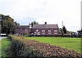
Congregational Chapel, Minshull Vernon
Minshull Vernon Congregational Chapel (1809) at the junction of Cross Lane, Eardwick Lane and Brookhouse Lane - seen from Cross Lane.
Image: © Mike Harris
Taken: 30 Sep 2007
0.04 miles