IMAGES TAKEN NEAR TO
Middlewich Road, CREWE, CW1 4RD
Introduction
This page details the photographs taken nearby to Middlewich Road, CW1 4RD by members of the Geograph project.
The Geograph project started in 2005 with the aim of publishing, organising and preserving representative images for every square kilometre of Great Britain, Ireland and the Isle of Man.

There are currently over 7.5m images from over14,400 individuals and you can help contribute to the project by visiting https://www.geograph.org.uk
Image Map
Images are licensed for reuse under creativecommons.org/licenses/by-sa/2.0
Notes
- Clicking on the map will re-center to the selected point.
- The higher the marker number, the further away the image location is from the centre of the postcode.
Image Listing (4 Images Found)
Images are licensed for reuse under creativecommons.org/licenses/by-sa/2.0
Image
Details
Distance
1

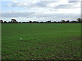
Young crop field and hedgerow
Off Middlewich Road (A530).
Image: © JThomas
Taken: 5 Nov 2016
0.13 miles
3
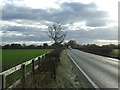
Looking south west on Middlewich Road (A530)
Image: © JThomas
Taken: 5 Nov 2016
0.19 miles
4
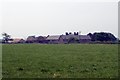
Dairy Farm, Minshull Vernon
Minshull Vernon. View from Crewe & Nantwich Circular Walk towards Dairy Farm. This farm is unimaginatively, but very appropriately, named! In the middle of flat dairy farming countryside north of Crewe.
Image: © Mike Harris
Taken: 5 Jul 2006
0.21 miles