IMAGES TAKEN NEAR TO
Warmingham Road, CREWE, CW1 4PP
Introduction
This page details the photographs taken nearby to Warmingham Road, CW1 4PP by members of the Geograph project.
The Geograph project started in 2005 with the aim of publishing, organising and preserving representative images for every square kilometre of Great Britain, Ireland and the Isle of Man.

There are currently over 7.5m images from over14,400 individuals and you can help contribute to the project by visiting https://www.geograph.org.uk
Image Map
Images are licensed for reuse under creativecommons.org/licenses/by-sa/2.0
Notes
- Clicking on the map will re-center to the selected point.
- The higher the marker number, the further away the image location is from the centre of the postcode.
Image Listing (6 Images Found)
Images are licensed for reuse under creativecommons.org/licenses/by-sa/2.0
Image
Details
Distance
1
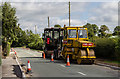
Warmingham Road
Roadworks on Warmingham Road in Coppenhall Moss.
Image: © Peter McDermott
Taken: 28 Aug 2017
0.02 miles
2
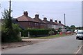
Warmingham Road at Coppenhall Moss, Crewe
Crewe. View along Warmingham Road at Coppenhall Moss. The edge of the urban sprawl - after this it is countryside.
Image: © Mike Harris
Taken: 5 Jul 2006
0.02 miles
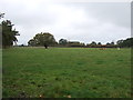
4
Minor road junction on Groby Road
Junction with Warmingham Road.
Image: © JThomas
Taken: 29 Oct 2016
0.10 miles
5
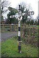
Direction Sign - Signpost by Warmingham Road, Coppenhall Moss
Pawn finial - 3 arms; Cheshire New CCC octagonal in parish of Shavington cum Gresty (Crewe and Nantwich District), junction of Warmingham Road with Groby Road.
Surveyed
Milestone Society National ID: CH_SJ7058
Image: © Milestone Society
Taken: Unknown
0.11 miles
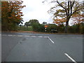
6
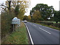
Entering Warmingham
Heading north on Warmingham Road.
Image: © JThomas
Taken: 29 Oct 2016
0.17 miles