IMAGES TAKEN NEAR TO
Broughton Road, CREWE, CW1 4NP
Introduction
This page details the photographs taken nearby to Broughton Road, CW1 4NP by members of the Geograph project.
The Geograph project started in 2005 with the aim of publishing, organising and preserving representative images for every square kilometre of Great Britain, Ireland and the Isle of Man.

There are currently over 7.5m images from over14,400 individuals and you can help contribute to the project by visiting https://www.geograph.org.uk
Image Map
Images are licensed for reuse under creativecommons.org/licenses/by-sa/2.0
Notes
- Clicking on the map will re-center to the selected point.
- The higher the marker number, the further away the image location is from the centre of the postcode.
Image Listing (7 Images Found)
Images are licensed for reuse under creativecommons.org/licenses/by-sa/2.0
Image
Details
Distance
1
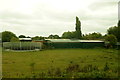
Crewe - Crewe Town footpath 13
Crewe. View along footpath Crewe Town 13. The main line railway (Crewe - Winsford - Liverpool) is to the right behind the bushes. The houses on the left are on Wareham Drive.
Image: © Mike Harris
Taken: 18 May 2008
0.19 miles
4
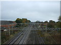
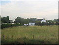
West Coast Main Line Railway towards Warrington
Looking north west from the bridge on Bradfield Road
Image: © JThomas
Taken: 29 Oct 2016
0.24 miles
5
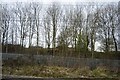
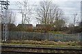
Trees by the West Coast Main line, Coppenhall
Image: © N Chadwick
Taken: 21 Mar 2016
0.24 miles
6
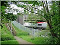
Crewe - footpath 13 and Moss Bridge
Crewe. View from Crewe Town footpath 13 at the foot of the steps up to Moss Bridge, which carries Parkers Road over the main line railway (Crewe - Winsford). Crewe-bound Virgin train.
Image: © Mike Harris
Taken: 18 May 2008
0.24 miles