IMAGES TAKEN NEAR TO
Whitley Place, CREWE, CW1 4GH
Introduction
This page details the photographs taken nearby to Whitley Place, CW1 4GH by members of the Geograph project.
The Geograph project started in 2005 with the aim of publishing, organising and preserving representative images for every square kilometre of Great Britain, Ireland and the Isle of Man.

There are currently over 7.5m images from over14,400 individuals and you can help contribute to the project by visiting https://www.geograph.org.uk
Image Map (Loading...)


Getting Data...Please wait
Leaflet Map data © OpenStreetMap
Images are licensed for reuse under creativecommons.org/licenses/by-sa/2.0
Notes
- Clicking on the map will re-center to the selected point.
- The higher the marker number, the further away the image location is from the centre of the postcode.
Image Listing (6 Images Found)
Images are licensed for reuse under creativecommons.org/licenses/by-sa/2.0
Image
Details
Distance
1
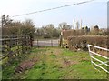
Footpath from Maw Green approaches Stoneley Road
The footpath approaches Stoneley Road near Stoneley Farm.
Image: © David P Howard
Taken: 22 Mar 2012
0.07 miles
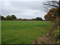
5
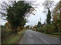
Groby Road
Looking north west near Groby Farm.
Image: © JThomas
Taken: 29 Oct 2016
0.21 miles
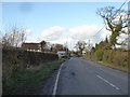
6
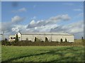
Voyager MPV facility near Crewe
Voyager is a specialist vehicle manufacturer, including taxis, wheelchair accessible vehicles and conversions.
Image: © Jonathan Hutchins
Taken: 30 Jan 2016
0.25 miles