IMAGES TAKEN NEAR TO
Villiers Russell Close, CREWE, CW1 4BF
Introduction
This page details the photographs taken nearby to Villiers Russell Close, CW1 4BF by members of the Geograph project.
The Geograph project started in 2005 with the aim of publishing, organising and preserving representative images for every square kilometre of Great Britain, Ireland and the Isle of Man.

There are currently over 7.5m images from over14,400 individuals and you can help contribute to the project by visiting https://www.geograph.org.uk
Image Map
Images are licensed for reuse under creativecommons.org/licenses/by-sa/2.0
Notes
- Clicking on the map will re-center to the selected point.
- The higher the marker number, the further away the image location is from the centre of the postcode.
Image Listing (6 Images Found)
Images are licensed for reuse under creativecommons.org/licenses/by-sa/2.0
Image
Details
Distance
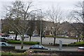
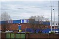
4
Crewe Market from Vernon Way
Looking towards the modern open air market area from the path alongside Vernon Way.
Image: © John S Turner
Taken: 16 Oct 2009
0.23 miles
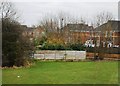
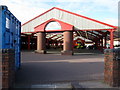
5
Heath Street
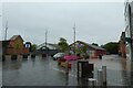
Looking across part of the market area in Crewe.
Image: © DS Pugh
Taken: 5 Aug 2023
0.23 miles
6
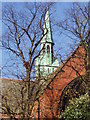
Coppenhall St Michael's church
The beautiful Coppenhall St Michael's church, situated off Ford Lane and Broad Street.
Image: © Crewe blog
Taken: 12 Nov 2005
0.24 miles