IMAGES TAKEN NEAR TO
Frank Bott Avenue, CREWE, CW1 3RW
Introduction
This page details the photographs taken nearby to Frank Bott Avenue, CW1 3RW by members of the Geograph project.
The Geograph project started in 2005 with the aim of publishing, organising and preserving representative images for every square kilometre of Great Britain, Ireland and the Isle of Man.

There are currently over 7.5m images from over14,400 individuals and you can help contribute to the project by visiting https://www.geograph.org.uk
Image Map
Images are licensed for reuse under creativecommons.org/licenses/by-sa/2.0
Notes
- Clicking on the map will re-center to the selected point.
- The higher the marker number, the further away the image location is from the centre of the postcode.
Image Listing (4 Images Found)
Images are licensed for reuse under creativecommons.org/licenses/by-sa/2.0
Image
Details
Distance
1
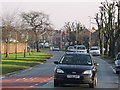
Bradfield Road
Bradfield Road looking towards Selworthy Drive
Image: © Crewe blog
Taken: 25 May 2006
0.10 miles
2
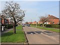
Road humps on Selworthy Drive
This whole area is plastered with these very large traffic calming road humps.
Image: © David P Howard
Taken: 22 Mar 2012
0.14 miles
4
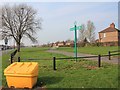
Leighton Greenway
Looking NNW along the greenway from the junction of Underwood Lane and Windsor Avenue. The Leighton Greenway is part of National Cycle Network route 75.
Image: © David P Howard
Taken: 22 Mar 2012
0.25 miles