IMAGES TAKEN NEAR TO
Ardleigh Close, CREWE, CW1 3PS
Introduction
This page details the photographs taken nearby to Ardleigh Close, CW1 3PS by members of the Geograph project.
The Geograph project started in 2005 with the aim of publishing, organising and preserving representative images for every square kilometre of Great Britain, Ireland and the Isle of Man.

There are currently over 7.5m images from over14,400 individuals and you can help contribute to the project by visiting https://www.geograph.org.uk
Image Map
Images are licensed for reuse under creativecommons.org/licenses/by-sa/2.0
Notes
- Clicking on the map will re-center to the selected point.
- The higher the marker number, the further away the image location is from the centre of the postcode.
Image Listing (6 Images Found)
Images are licensed for reuse under creativecommons.org/licenses/by-sa/2.0
Image
Details
Distance
1
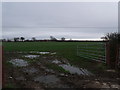
Leighton Primary School in the distance.
The school was Tottys Hall School many years ago.
Image: © Moston-Harratt
Taken: 9 Jan 2012
0.15 miles
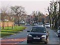
2
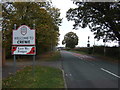
Welcome to Crewe
Looking south on Minshill New Road
Image: © JThomas
Taken: 29 Oct 2016
0.16 miles
3
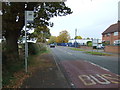
Bus stop on Minshill New Road
Looking north.
Image: © JThomas
Taken: 29 Oct 2016
0.16 miles
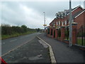
5
Bradfield Road
Bradfield Road looking towards Selworthy Drive
Image: © Crewe blog
Taken: 25 May 2006
0.24 miles
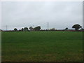
6
Minshull New Road, Crewe
New properties with views over Cheshire farmland
Image: © Margaret Sutton
Taken: 20 Aug 2007
0.24 miles