IMAGES TAKEN NEAR TO
Dale Way, CREWE, CW1 3GT
Introduction
This page details the photographs taken nearby to Dale Way, CW1 3GT by members of the Geograph project.
The Geograph project started in 2005 with the aim of publishing, organising and preserving representative images for every square kilometre of Great Britain, Ireland and the Isle of Man.

There are currently over 7.5m images from over14,400 individuals and you can help contribute to the project by visiting https://www.geograph.org.uk
Image Map
Images are licensed for reuse under creativecommons.org/licenses/by-sa/2.0
Notes
- Clicking on the map will re-center to the selected point.
- The higher the marker number, the further away the image location is from the centre of the postcode.
Image Listing (28 Images Found)
Images are licensed for reuse under creativecommons.org/licenses/by-sa/2.0
Image
Details
Distance
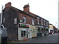
1
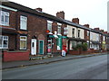
Post Office on West Street, Crewe
Showing position of Postbox No. CW1 3.
See Image] for postbox.
Image: © JThomas
Taken: 29 Oct 2016
0.08 miles
2
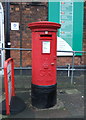
George V postbox outside Post Office on West Street, Crewe
Postbox No. CW1 3.
See Image] for context.
Image: © JThomas
Taken: 29 Oct 2016
0.08 miles
5
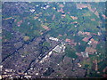
Crewe, seen from over Sandbach
The Crewe-Chester Railway crosses the image diagonally; the Crewe-Manchester line crosses along the bottom. The large pale, squarish building by the railway in the centre is the Bentley Motors car plant, the long buildings to the lower left of Bentley is the Bombardier train manufacturing plant, and the wooded circle above is Queen's Park.
Image: © M J Richardson
Taken: 26 Sep 2015
0.13 miles
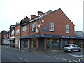
6
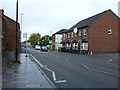
The Brunel Arms public house, Crewe
On West Street.
Image: © JThomas
Taken: 29 Oct 2016
0.15 miles
7
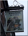
Sign for the Brunel Arms public house, Crewe
Image: © JThomas
Taken: 29 Oct 2016
0.15 miles
9
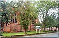
St Barnabas church
Situated in West Street, Crewe.
Image: © Margaret Sutton
Taken: 20 Aug 2007
0.16 miles
10
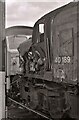
Wrecked locomotive
The damage to British Rail Class 40 No. 40 189 is obvious. The locomotive was involved in the Weaver Junction crash on 6 August 1975. It was hauling a freight train which was unable to stop due to a lack of brake power, over-ran a signal and collided with another freight train. Seen during the Crewe Works Open Day, 1975.
Location within Crewe Works where photographed is a guess.
Image: © Richard Sutcliffe
Taken: 20 Sep 1975
0.17 miles