IMAGES TAKEN NEAR TO
Mayfield Mews, CREWE, CW1 3FZ
Introduction
This page details the photographs taken nearby to Mayfield Mews, CW1 3FZ by members of the Geograph project.
The Geograph project started in 2005 with the aim of publishing, organising and preserving representative images for every square kilometre of Great Britain, Ireland and the Isle of Man.

There are currently over 7.5m images from over14,400 individuals and you can help contribute to the project by visiting https://www.geograph.org.uk
Image Map
Images are licensed for reuse under creativecommons.org/licenses/by-sa/2.0
Notes
- Clicking on the map will re-center to the selected point.
- The higher the marker number, the further away the image location is from the centre of the postcode.
Image Listing (13 Images Found)
Images are licensed for reuse under creativecommons.org/licenses/by-sa/2.0
Image
Details
Distance
2
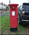
George V postbox on Minshill New Road, Crewe
Postbox No. CW1 129.
See Image] for context.
Image: © JThomas
Taken: 29 Oct 2016
0.09 miles
3
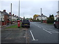
Minshill New Road, Crewe
Looking north showing position of Postbox No. CW1 129.
See Image] for postbox.
Image: © JThomas
Taken: 29 Oct 2016
0.09 miles
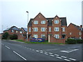
4
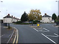
Roundabout on Minshill New Road, Crewe
Looking north.
Image: © JThomas
Taken: 29 Oct 2016
0.12 miles
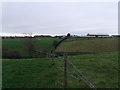
5
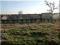
Leighton Brook
To the far right of the photo is a fence that now blocks access to Leighton Brook.
Image: © Moston-Harratt
Taken: 9 Jan 2012
0.15 miles
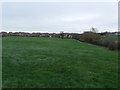
7
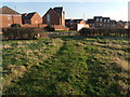
Looking towards Pyms Lane
Bentley Motors is in the distance,
Image: © Moston-Harratt
Taken: 8 Jan 2012
0.19 miles
8
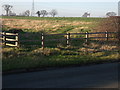
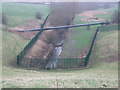
Now fenced off the old Drive way to Totty's Hall farm
Image: © Moston-Harratt
Taken: 13 Jan 2012
0.20 miles
10
Leighton Brook
Sewage pipe runs across the brook
Image: © Moston-Harratt
Taken: 9 Jan 2012
0.22 miles