IMAGES TAKEN NEAR TO
Harrison Drive, CREWE, CW1 3DA
Introduction
This page details the photographs taken nearby to Harrison Drive, CW1 3DA by members of the Geograph project.
The Geograph project started in 2005 with the aim of publishing, organising and preserving representative images for every square kilometre of Great Britain, Ireland and the Isle of Man.

There are currently over 7.5m images from over14,400 individuals and you can help contribute to the project by visiting https://www.geograph.org.uk
Image Map
Images are licensed for reuse under creativecommons.org/licenses/by-sa/2.0
Notes
- Clicking on the map will re-center to the selected point.
- The higher the marker number, the further away the image location is from the centre of the postcode.
Image Listing (98 Images Found)
Images are licensed for reuse under creativecommons.org/licenses/by-sa/2.0
Image
Details
Distance
1
Mavor Court, Flag Lane, Crewe
Managed by Guinness Partnership Wulvern, Mavor Court is age-exclusive housing containing 17 flats. New residents must be at least 50 years old. A plaque on the building records the official opening of Mavor Court by the Mayor of Crewe on December 8th 1986.
Image: © Jaggery
Taken: 15 Feb 2017
0.05 miles
2
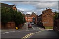
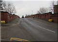
Flag Lane
View looking up Flag Lane from Flag Lane Bridge.
Image: © Peter McDermott
Taken: 28 Aug 2017
0.05 miles
3
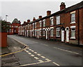
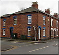
Long row of houses, Flag Lane, Crewe
North of the Delamere Street junction.
Image: © Jaggery
Taken: 15 Feb 2017
0.06 miles
4
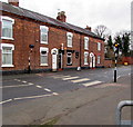
Zebra crossing, Flag Lane, Crewe
Near the corner of Delamere Road. Although Belisha beacons had marked pedestrian crossings in the UK from 1934, it was not until 1951 that the now familiar black and white stripes stretching across the width of the road were officially introduced. Previously, there were only metal studs across the road surface.
Image: © Jaggery
Taken: 15 Feb 2017
0.06 miles
5
Telecoms cabinets on a Crewe corner
The cabinets are on the Delamere Street side of the Flag Lane corner.
Image: © Jaggery
Taken: 15 Feb 2017
0.06 miles
6
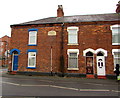
Whitmore Place 1877 Crewe
The tablet on the Flag Lane house wall shows WHITMORE PLACE 1877.
The name does not appear to be in use in 2017.
The corner of Delamere Street is on the left.
Image: © Jaggery
Taken: 15 Feb 2017
0.06 miles
7
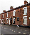
Lilli's Beauty & Barber shop in Crewe
At 72 Flag Lane, near the corner of Delamere Street.
Image: © Jaggery
Taken: 15 Feb 2017
0.06 miles
8
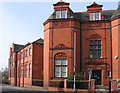
Crewe - former Technical Institute
"The former Technical Institute is prominent amongst the Flag Lane buildings, a fine example in red brick, constructed in 1897 to the design of James Stevens of Manchester and Macclesfield for The Technical Institute Committee" - see http://cheshireeast-consult.limehouse.co.uk/portal/planning/spd/locallist?pointId=1299169990184 . For an alternative view, please see Image
Image: © Dave Bevis
Taken: 4 Mar 2013
0.07 miles
9
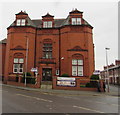
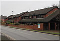
Hightown Apartments, Crewe
The redbrick building on the corner of Flag Lane and Richard Moon Street is a former Technical Institute constructed in 1897.
Image: © Jaggery
Taken: 15 Feb 2017
0.07 miles
10
Yellow grit boxes at the northern end of Flag Lane road bridge, Crewe
The bridge carries Flag Lane over the A5078 Dunwoody Road and railway lines.
Image: © Jaggery
Taken: 15 Feb 2017
0.08 miles