IMAGES TAKEN NEAR TO
Richard Street, CREWE, CW1 3AG
Introduction
This page details the photographs taken nearby to Richard Street, CW1 3AG by members of the Geograph project.
The Geograph project started in 2005 with the aim of publishing, organising and preserving representative images for every square kilometre of Great Britain, Ireland and the Isle of Man.

There are currently over 7.5m images from over14,400 individuals and you can help contribute to the project by visiting https://www.geograph.org.uk
Image Map
Images are licensed for reuse under creativecommons.org/licenses/by-sa/2.0
Notes
- Clicking on the map will re-center to the selected point.
- The higher the marker number, the further away the image location is from the centre of the postcode.
Image Listing (58 Images Found)
Images are licensed for reuse under creativecommons.org/licenses/by-sa/2.0
Image
Details
Distance
1
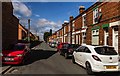
Richard Moon Street
Richard Moon Street in Crewe.
Image: © Peter McDermott
Taken: 28 Aug 2017
0.07 miles
2
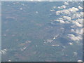
Crewe - the railway town
Three lines radiating northeast [upper left] to Manchester, north [centre left] to Warrington and Scotland, and northwest [lower left] to Chester.
Image: © M J Richardson
Taken: 7 Oct 2010
0.09 miles
3
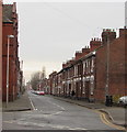
Richard Moon Street, Crewe
Viewed across Flag Lane. Richard Moon (Sir Richard Moon from 1887) was Chairman of the Board of Directors of the LNWR (London & North Western Railway) from 1861-1891.
Image: © Jaggery
Taken: 15 Feb 2017
0.10 miles
4
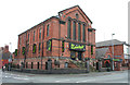
The Limelight, Hightown, Crewe
This live music venue closed in January 2010; the building is up for redevelopment. The large red-brick building is a former church
Image: © Espresso Addict
Taken: 30 Mar 2012
0.14 miles
6
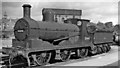
Ex-L&Y 0-6-0 as a Crewe Works Pilot
Aspinall 27 Class 3F 0-6-0 No. 52441 (built 1890s, withdrawn 9/62) was employed in its final years as one of the several Crewe Works Pilots. [N.B.: I need help, please, with the precise location of my several images taken at Crewe Works, because I don't have a contemporary large-scale plan of the Works complex?]
Image: © Ben Brooksbank
Taken: 6 Aug 1958
0.14 miles
7
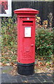
Elizabeth II postbox on West Street, Crewe
Postbox No. CW1 114.
See Image] for context.
Image: © JThomas
Taken: 29 Oct 2016
0.14 miles
8
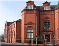
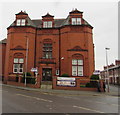
Crewe - former Technical Institute
"The former Technical Institute is prominent amongst the Flag Lane buildings, a fine example in red brick, constructed in 1897 to the design of James Stevens of Manchester and Macclesfield for The Technical Institute Committee" - see http://cheshireeast-consult.limehouse.co.uk/portal/planning/spd/locallist?pointId=1299169990184 . For an alternative view, please see Image
Image: © Dave Bevis
Taken: 4 Mar 2013
0.14 miles
9
Hightown Apartments, Crewe
The redbrick building on the corner of Flag Lane and Richard Moon Street is a former Technical Institute constructed in 1897.
Image: © Jaggery
Taken: 15 Feb 2017
0.14 miles
10
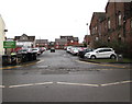
Browning Street Free Car Park, Crewe
Viewed from the Flag Lane entrance looking towards Browning Street.
Image: © Jaggery
Taken: 15 Feb 2017
0.15 miles