IMAGES TAKEN NEAR TO
St. Marys Street, CREWE, CW1 2JU
Introduction
This page details the photographs taken nearby to St. Marys Street, CW1 2JU by members of the Geograph project.
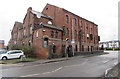
The Geograph project started in 2005 with the aim of publishing, organising and preserving representative images for every square kilometre of Great Britain, Ireland and the Isle of Man.

There are currently over 7.5m images from over14,400 individuals and you can help contribute to the project by visiting https://www.geograph.org.uk
Image Map
Images are licensed for reuse under creativecommons.org/licenses/by-sa/2.0
Notes
- Clicking on the map will re-center to the selected point.
- The higher the marker number, the further away the image location is from the centre of the postcode.
Image Listing (108 Images Found)
Images are licensed for reuse under creativecommons.org/licenses/by-sa/2.0
Image
Details
Distance
1
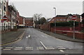
North along Gatefield Street, Crewe
One-way street extending for 120 metres from Delamere Street to Victoria Street.
Image: © Jaggery
Taken: 15 Feb 2017
0.01 miles
2
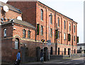
Steps up to Crewe Liberal Club
The St Mary's Street side of the club at 1 Gatefield Street in Crewe.
Image: © Jaggery
Taken: 15 Feb 2017
0.02 miles
3
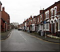
North along St Mary's Street, Crewe
One-way street extending north for 120 metres from Delamere Street to Flag Lane.
Image: © Jaggery
Taken: 15 Feb 2017
0.02 miles
4
Crewe - former chapel on Flag Lane
This was used as the Limelight nightclub until it closed in January 2010. For an alternative view, please see Image
Image: © Dave Bevis
Taken: 4 Mar 2013
0.02 miles
5
Former Limelight music club in Hightown, Crewe
Disused building at the eastern end of Flag Lane, viewed in February 2017.
Image: © Jaggery
Taken: 15 Feb 2017
0.02 miles
7
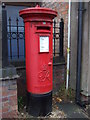
George VI postbox on Hightown, Crewe
Postbox No. CW1 21.
See Image] for context.
Image: © JThomas
Taken: 29 Oct 2016
0.04 miles
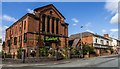
8
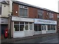
Shops on Hightown, Crewe
Showing position of Postbox No. CW1 21.
See Image] for postbox.
Image: © JThomas
Taken: 29 Oct 2016
0.04 miles
9
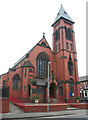
St Mary's Church, Crewe: west front
Grade-II-listed red-brick Roman Catholic church by Pugin & Pugin dating from 1890-1. This view of the front (west) is from St Mary's Road and shows the narrow square tower on the SW corner. See Image for the view from the rear
Image: © Espresso Addict
Taken: 30 Mar 2012
0.05 miles
10
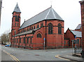
St Mary's Church, Crewe: rear view
Grade-II-listed red-brick Roman Catholic church by Pugin & Pugin dating from 1890-1. This view of the rear is from Delamere Street; the junction with Gatefield Street is on the right. See Image for the view from the front
Image: © Espresso Addict
Taken: 30 Mar 2012
0.05 miles