IMAGES TAKEN NEAR TO
Delamere Street, CREWE, CW1 2ER
Introduction
This page details the photographs taken nearby to Delamere Street, CW1 2ER by members of the Geograph project.
The Geograph project started in 2005 with the aim of publishing, organising and preserving representative images for every square kilometre of Great Britain, Ireland and the Isle of Man.

There are currently over 7.5m images from over14,400 individuals and you can help contribute to the project by visiting https://www.geograph.org.uk
Image Map
Images are licensed for reuse under creativecommons.org/licenses/by-sa/2.0
Notes
- Clicking on the map will re-center to the selected point.
- The higher the marker number, the further away the image location is from the centre of the postcode.
Image Listing (177 Images Found)
Images are licensed for reuse under creativecommons.org/licenses/by-sa/2.0
Image
Details
Distance
1
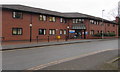
Delamere Resource Centre, Crewe
Cheshire & Wirral Partnership NHS Foundation Trust premises at 45 Delamere Street.
Image: © Jaggery
Taken: 15 Feb 2017
0.01 miles
2
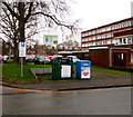
Delamere Street recycling area, Crewe
The green bin is for shoes and clothes. The blue bin is for shoes.
Image: © Jaggery
Taken: 15 Feb 2017
0.01 miles
3

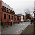
Car park on Chester Street
Looking towards Wellington House.
Image: © DS Pugh
Taken: 5 Aug 2023
0.01 miles
4
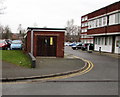
Delamere Street electricity substation, Crewe
The SP Manweb electricity substation identifier 06/7055/021 is at the edge of a car park.
Wellington House http://www.geograph.org.uk/photo/5294442 is on the right.
Image: © Jaggery
Taken: 15 Feb 2017
0.02 miles
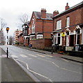
5
East along Delamere Street, Crewe
Between St Mary's Street and Gatefield Street. The southern edge of St Mary's RC Church is on the left. http://www.geograph.org.uk/photo/5294357
Image: © Jaggery
Taken: 15 Feb 2017
0.03 miles
6
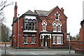
47 Delamere Street, Crewe
This substantial grade-II-listed red-brick house dates from 1850, which puts it among the older surviving buildings in Crewe. It features an elaborate timber porch and a large oriel window (left). Built as a railway manager's house, it has also housed a convent. St Mary's Roman Catholic church stands opposite (just visible right); see Image
Image: © Espresso Addict
Taken: 30 Mar 2012
0.03 miles
7
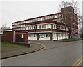
Wellington House, Crewe
Office block at 38-44 Delamere Street, on the corner of Lawrence Street. Among its occupiers in February 2017 are Job Centre Plus, Welcome Finance and Central Cheshire Public Health Development Team.
Image: © Jaggery
Taken: 15 Feb 2017
0.03 miles
8
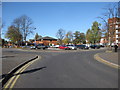
Holly Bank car park
Looking towards Holly Bank car park from Chester Street.
Image: © John S Turner
Taken: 16 Oct 2009
0.03 miles
9
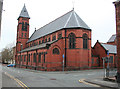
St Mary's Church, Crewe: rear view
Grade-II-listed red-brick Roman Catholic church by Pugin & Pugin dating from 1890-1. This view of the rear is from Delamere Street; the junction with Gatefield Street is on the right. See Image for the view from the front
Image: © Espresso Addict
Taken: 30 Mar 2012
0.04 miles
10
Zebra crossing, Delamere Street, Crewe
Across Delamere Street between the St Mary's Street junction and the Gatefield Street junction.
Image: © Jaggery
Taken: 15 Feb 2017
0.04 miles