IMAGES TAKEN NEAR TO
Forge Street, CREWE, CW1 2DU
Introduction
This page details the photographs taken nearby to Forge Street, CW1 2DU by members of the Geograph project.
The Geograph project started in 2005 with the aim of publishing, organising and preserving representative images for every square kilometre of Great Britain, Ireland and the Isle of Man.

There are currently over 7.5m images from over14,400 individuals and you can help contribute to the project by visiting https://www.geograph.org.uk
Image Map
Images are licensed for reuse under creativecommons.org/licenses/by-sa/2.0
Notes
- Clicking on the map will re-center to the selected point.
- The higher the marker number, the further away the image location is from the centre of the postcode.
Image Listing (224 Images Found)
Images are licensed for reuse under creativecommons.org/licenses/by-sa/2.0
Image
Details
Distance
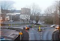
2
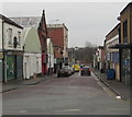
High Street, Crewe
Looking ESE along High Street, a one-way street.
Image: © Jaggery
Taken: 15 Feb 2017
0.06 miles
3
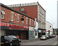
Steam Nightclub, High Street, Crewe
The High Street is now a rather unappealing backstreet off Edleston Road. The tall Steam Nightclub building has been operated as a nightclub under a variety of names for many years. Its impressive front facade is rather out of place these days. The side lettering, prominent from the railway bridge on Edleston Road, reads 'Kettell's Restaurant'
Image: © Espresso Addict
Taken: 30 Mar 2012
0.06 miles
6
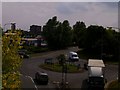
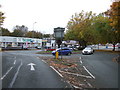
Vernon Way Roundabout
Taken from the footbridge over Vernon Way and shows the entrance to The Heritage centre and Tesco with Rail House and Waverley Court in the distance.
Image: © Terry Hughes
Taken: 25 Jun 2009
0.07 miles
9
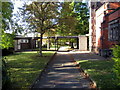
Pathway beside Christ Church
Christ Church was built in 1845 and partly demolished in 1977. The remaining buildings are on the right, and the modern church hall is on the left.
Image: © John S Turner
Taken: 16 Oct 2009
0.09 miles
10
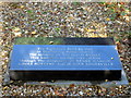
Plaque in Christ Church Memorial Garden
This plaque is within the area that was once inside Christ Church. Built in 1845 the church was partly demolished between 1977-1979. The open space is now a memorial garden, and services are still held in the parts of the building that remain.
Image: © John S Turner
Taken: 16 Oct 2009
0.09 miles