IMAGES TAKEN NEAR TO
Prince Albert Street, CREWE, CW1 2DF
Introduction
This page details the photographs taken nearby to Prince Albert Street, CW1 2DF by members of the Geograph project.
The Geograph project started in 2005 with the aim of publishing, organising and preserving representative images for every square kilometre of Great Britain, Ireland and the Isle of Man.

There are currently over 7.5m images from over14,400 individuals and you can help contribute to the project by visiting https://www.geograph.org.uk
Image Map
Images are licensed for reuse under creativecommons.org/licenses/by-sa/2.0
Notes
- Clicking on the map will re-center to the selected point.
- The higher the marker number, the further away the image location is from the centre of the postcode.
Image Listing (190 Images Found)
Images are licensed for reuse under creativecommons.org/licenses/by-sa/2.0
Image
Details
Distance
1
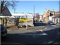
The Salvation Army Worship Centre
The corner of the Salvation Army building on Prince Albert Street, at its junction with Chester Street.
Image: © John S Turner
Taken: 16 Oct 2009
0.01 miles
2
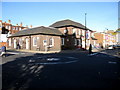
'the Waldron', Crewe
Looking across the junction of Prince Albert Street and Chester Street towards 'the Waldron'.
Image: © John S Turner
Taken: 16 Oct 2009
0.01 miles
3
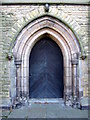
The west door of Christ Church, Crewe
This west door is set in to the base of the freestanding tower of Christ Church. The church was built in 1845, but was partly demolished between 1977 and 1979 due to dry rot. The tower still stands, along with a section of the building at the opposite end of the site. See also Image and Image
Image: © John S Turner
Taken: 16 Oct 2009
0.01 miles
4
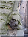
Male stone head on Christ Church west doorway
This male stone head is on the north side of the west door in the base of the tower of Christ Church - Image
Image: © John S Turner
Taken: 16 Oct 2009
0.01 miles
5
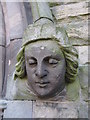
Female stone head on Christ Church west doorway
This female stone head is on the south side of the west door in the base of Christ Church tower - Image
Image: © John S Turner
Taken: 16 Oct 2009
0.01 miles
6
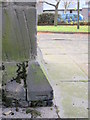
Bench mark on Christ Church tower
This bench mark is on one of the buttresses on the north side of the tower of Christ Church. It is only just above the level of the raised flagged area around this part of the tower, and it is also partially covered with moss.
Image: © John S Turner
Taken: 2 Nov 2009
0.02 miles
7
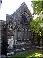
Part of the remains of Christ Church, Crewe
This small gable end is part of the west end of Christ Church which was built in 1845, but was partly demolished between 1977-1979 due to dry rot. Sections of the church do still stand and services are held there. http://www.scfhs.org.uk/scfhs/christchurch_crewe_intro.html
Image: © John S Turner
Taken: 16 Oct 2009
0.02 miles
8
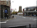
Market Street junction with Chester Street
Looking across Market Street from its junction with Chester Street. The tower of Christ Church can be seen in the distance.
Image: © John S Turner
Taken: 16 Oct 2009
0.02 miles
9
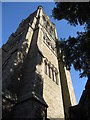
Tower of Christ Church, Crewe
The freestanding tower of Christ Church, which was retained when a large part of the church was demolished between 1977-1979 due to dry rot. Part of the church is still in use. http://www.scfhs.org.uk/scfhs/christchurch_crewe_intro.html
The tower still contains a full ring of ten bells (more than most churches which rarely have more than eight) and is highly regarded in bell ringing circles. http://dove.cccbr.org.uk/detail.php?searchString=crewe&Submit=+Go+&DoveID=CREWE
(Thanks to Stephen Craven for the information regarding the bells)
Image: © John S Turner
Taken: 16 Oct 2009
0.02 miles
10
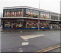
Furniture Brothers in Crewe town centre
Furniture shop at 22A Market Street, on the corner of Chester Street.
Image: © Jaggery
Taken: 15 Feb 2017
0.03 miles