IMAGES TAKEN NEAR TO
Hawthorne Close, CONGLETON, CW12 4UF
Introduction
This page details the photographs taken nearby to Hawthorne Close, CW12 4UF by members of the Geograph project.
The Geograph project started in 2005 with the aim of publishing, organising and preserving representative images for every square kilometre of Great Britain, Ireland and the Isle of Man.

There are currently over 7.5m images from over14,400 individuals and you can help contribute to the project by visiting https://www.geograph.org.uk
Image Map
Images are licensed for reuse under creativecommons.org/licenses/by-sa/2.0
Notes
- Clicking on the map will re-center to the selected point.
- The higher the marker number, the further away the image location is from the centre of the postcode.
Image Listing (5 Images Found)
Images are licensed for reuse under creativecommons.org/licenses/by-sa/2.0
Image
Details
Distance
1
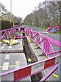
Gas main renewal works, Back Lane
Here, the works are at the junction with Longdown Road, looking north west.
Image: © Richard Dorrell
Taken: 19 Mar 2012
0.08 miles
2
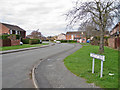
Chestnut Drive, West Heath
A residential road viewed from Longdown Road. The picture shows typical housing and layout of the roads in this large private estate, which lies to the west of Congleton town.
Image: © Richard Dorrell
Taken: 19 Mar 2012
0.09 miles
3
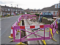
Road works in Longdown Road
The works are replacement of a gas main. This location is close to the junction with Back Lane.
Image: © Richard Dorrell
Taken: 19 Mar 2012
0.09 miles
4
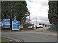
Entrance to Radnor Park Trading Estate
The entrance is from a turning off Back Lane, in the West Heath part of Congleton. As the signs show, significant parts of the site are currently for sale or for let.
Image: © Richard Dorrell
Taken: 19 Mar 2012
0.13 miles
5
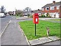
Post box in Longdown Road, West Heath
This is within a large private housing estate to the west of Congleton town centre.
Image: © Richard Dorrell
Taken: 19 Mar 2012
0.19 miles